| Hills of Boston Shawmut Peninsula, Mass. |
| | Introduction | Hills | Maps | Sources | |
| Shawmut Peninsula is the promontory of land on which Boston, Mass. was built. The name is thought to derive from a Native Americam term for "living fountains." The first settled was William Blaxton (Blackstone), an Episcopalian minister. He had been on the peninsula living by himself for several years when John Winthrop leading a Puritan fleet arrived first landing in nearby Charlestown. Blaxton invited them to settle on his land in Boston after they had problems finding potable water. The Puritans granted him 50 acres of land, but disapproving of Puritan intolerance Blaxton sold the land back and left for what would become Rhode Island, becoming its first settler. |
|
| Hills of Boston Shawmut Peninsula, Mass. |
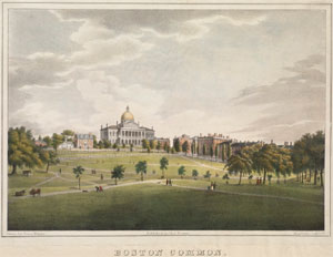
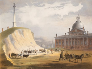
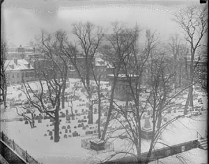
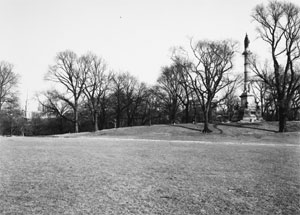
| Beacon Hill (Trimountain #1) |
| • |
USGS identified - MassMapper MassGIS |
| • |
Google Maps | Google Earth - Google Maps |
| • |
"...No picture, map, or satisfactory account of the ancient peninsula of Shawmut, as it appeared to Winthrop and his colonists, has been discovered; but from the abundant descriptions of later times there needs no great effort of the imagination to bring it clearly to mind.....", Topography and Landmarks of the Colonial Period, Edwin L. Bynner, The Memorial History of Boston, pg. 521, 1881 - Internet Archive |
| • |
"...The etymology of the word Trimountain leads us directly to the origin of that name. Shawmut presented to those who viewed it from Charlestown, the appearance only of three large hills ; one on the north, one far to the east, and another forming the whole western extremity of the place. On the last were three lofty and majestic eminences, and on the brow of the easternmost of these, three little rising hillocks appeared in a contiguous range. The combination of these circumstances doubtless gave rise to the name of Trimountain.....", Snow, Pg. 33, 1828 - Internet Archive |
| • |
History of the Boston Landfill Project: How Boston Lost Its Hills, "...The peninsula had five hills, one hill that would later be named Trimount (meaning triple mountain) that actually consisted of three hills itself: Mt. Vernon, Beacon hill and Pemberton hill, and two other hills the settlers later called Copp’s Hill and Fort Hill....." - History of Massachusetts Blog |
| • |
"...In speaking of Sentry Hill, Shaw says 'by the first settlers' of Charlestown it was called Tre-mount, on account of its three hills, which to them appeared in range. These were not, 'however, Beacon, Copp's and Fort Hills, as generally supposed, but three little rising hills on the top of a high mountain on the north-west side of the town...", Wheildon, pg. 13, 1877 - HathiTrust |
| • |
Beacon Hill - USGS Geographic Names Information System
Variant names: Centry Hill, Sentry Hill, Sentry Peak, Tramont, Treamount, Tremont, Trimountain |
|
| Copps Hill |
| • |
USGS identified - MassMapper MassGIS |
| • |
Google Maps | Google Earth - Google Maps |
| • |
"...The hill at the north, rising to the height of about 50 feet above the sea, presented then on its northwest brow an abrupt declivity, long after known as Copp's hill steeps....This hill was the spot selected for the site of the first windmill used in the colony, when it was brought down from Watertown, in August 1632, because it would not grind there but with a westerly wind. Hence it obtained the name of Windmill hill. Most probably it was at some period called Snow hill; but about the time of the revolution in 1775, it bore the name
of Copp, which it retained so long as any portion of it was left standing....William Copp was the earliest proprietor of that portion of the hill which latterly bore his name...", Snow, Pg. 105, 1828 - Internet Archive |
| • |
"...Copp's Hill, known originally as Mill Hill and then Snow Hill, is the northernmost promontory of the Boston peninsula that overlooks the Charles River estuary, Charlestown, and Bunker Hill...", Buildings and Landmarks of Old Boston, Howard S. Andros, 2001 - Google ebook preview |
| • |
"...Mill or Snow hill, and afterwards (as now) Copp's hill. William Copp, a shoe maker, took the oath in 1641, and owned the mill....", Wheildon, pg. 11, 1877 - HathiTrust |
| • |
Copps Hill - USGS Geographic Names Information System
Variant Names: Corpse Hill, Snows Hill, Windmill Hill- |
|
| Flagstaff Hill |
| • |
USGS identified - MassMapper MassGIS |
| • |
Google Maps | Google Earth - Google Maps |
| • |
"...Powder House Hill, more recently called Flag-staff Hill was situated in what was the central part of the Common, before Charles street was laid out. It is to be seen delineated in all the ancient maps of the town, and was from very early times appropriated, as its name indicates, for a site for the town's powder-house...", Shurtleff, Pg. 344, 1871 - Internet Archive |
| • |
"...On the hill formerly known as Flagstaff Hill, but now dedicated to the soldiers' monument, the artillery was posted, protected by intrenchments...", DeWolf, pg. 42, 1910 - Internet Archive |
| • |
Flagstaff Hill - USGS Geographic Names Information System |
|
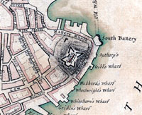
| Fort Hill |
| • |
Google Maps | Google Earth - Google Maps |
| • |
"...Fort Hill, the second of the three great hills of Boston, was situated at the easterly part of the town, on the
promontory that projected easterly between the Great Cove at its north and the South Cove at its south. It was estimated, before any alteration had taken place in the contour of its summit...The land immediately around this hill was designated was
used so extensively at first for the cultivation of corn that the eminence had previously obtained the name of
Corn Hill", Shurtleff, Pg. 162, 1871 - Internet Archive |
| • |
"...From the south-east margin of this, which we will call the middle-cove, the eastern hill commenced its ascent, and extending gradually to the south and west rose to the height of 80 feet above the sea. Its eastern side was also a ragged cliff, that seemed placed by nature in front of the entrance to the harbour for the purposes of defence, to which it was very soon applied, and from which it obtained its present name of Fort-hill. It was before called Corn-hill...", Snow, 1828, Pg. 110 - Internet Archive |
| • |
Fort Hill - And This Is Good Old Boston |
| • |
Fort Hill (Historical) - USGS Geographic Names Information System |
|
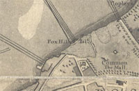
| Fox Hill |
| • |
Google Maps | Google Earth - Google Maps |
| • |
"...The little elevation mentioned by the name of Fox Hill [near the present 'Centre Gate' of the Public Garden on Charles Street] was nearly or quite surrounded by water at times, and was hence called the island; on this was a small redoubt...", DeWolf, pg. 42, 1910 - Internet Archive |
| • |
"...Fox Hill was on the westerly edge of the Common, not far from the place in the Public Garden assigned for
a tower, and which projects into the pond that was artificially commenced there on the fourteenth of November,
1859. It must not be mistaken for West Hill, one of the westernmost heads of Beacon Hill, and which was
situated very near Cambridge street. This hill was not very large, being about twenty feet in height and fifty
feet in diameter, and was almost surrounded by water, being on the edge of the part of Charles River generally
known as the Back Bay...", Shurtleff, pg. 346, 1871 - Internet Archive |
|
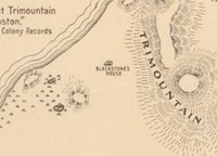
| Mount Vernon (Trimountain #2) |
| • |
USGS identified - MassMapper MassGIS (Historical) |
| • |
Google Maps | Google Earth - Google Maps |
| • |
"...The third hill was at the western extremity of the range, and was variously called Copley's Hill, Mount Vernon and Mount Horam, and possibly some other impolite names...Before the settlement it was West Hill...", Wheildon, pg. 17, 1877 - HathiTrust |
| • |
"... this results would place his [Blackstone's] house and orchard on a plat stretching on Beacon Street from near Spruce to the water, and back so as to include what was later known as West Hill, the most westerly of the summits of 'Trimountain'...", Winsor, Vol. 1, pg. 84 - Internet Archive |
| • |
"... During Copley's [painter John Singleton Copley] ownership this part if the hill was generally called 'Copley's Hill.'..", Bacon, pg. 84 - Google ebook |
| • |
"...Another portion of the ancient Treamount stretched nearly to the present line of West Cedar street, where it
terminated in a high bluff called West Hill - a portion of the ridge enjoying names which it would be much
better to forget than to continue in remembrance with the unpleasant associations of the past with which they
are inseparably connected...", Shurtleff, Pg. 171, 1871 - Internet Archive |
| • |
The Original Mount Whoredom, "...'Mount Whoredom,' the name documents and maps from around the Revolution gave to a hill that real-estate developers in the early republic renamed 'Mount Vernon.'..." - Boston 1775 |
| • |
Mount Vernon (Historical) - USGS Geographic Names Information System
Variant names: Compleys Hill, Mount Hoardam, Mount Whoredom |
|
| Pemberton Hill (Trimountain #3) |
| • |
Google Maps | Google Earth - Google Maps |
| • |
"...The first of the three Little Hills which constituted the range as seen from Charlestown, received the name of Cotton Hill, and afterwards Pemberton Hill. Drake says, 'Cotton Hill was an eminence near the southerly termination of Pemberton Square, and nearly opposite the gate of King's Chapel Burying Ground. The Rev. John Cotton resided near it, (now Tremont Row,) and hence its name.'...", Wheildon, pg. 14, 1877 - HathiTrust |
| • |
"...Old 'Treamount Street' began in 1708, at the extreme corner of Court Street and Tremont Bow, as they now are, and extended around the base of what was first called Cotton Hill (so called as late as 1733), from the residence of Bev. John Cotton ; subsequently Pemberton Hill, from James Pemberton, a later resident at the north end of what is now Pemberton Square.'...", Drake, pg. 47, 1900 - Internet Archive |
| • |
"...James Pemberton bought in 1734 from the estate of Rev. Henry Harris his cousin's husband, land at the northerly end of what is now Pemberton Sq., and from this circumstance and its possession for half a century the square takes the name...", The Pemberton Family, pg. 6 , Walter K. Watkins, 1892 - Internet Archive |
| • |
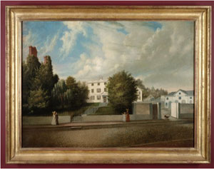
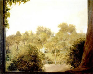
Gardiner Greene, "...In 1803 Greene bought land in Boston on Pemberton Hill (i.e. Cotton Hill)...The estate was known for its sweeping harbor views and lush 'hillside garden'..." - Wikipedia |
| • |
"...Mr. Greene died in 1832, and the estate...was sold to Mr. Patrick T. Jackson...He employed Mr. Asa G. Sheldon to cut down the hill and carry away the soil to the western part of the old Mill Pond...The English elms on the top of the hill were sold for timber to the Charlestown Navy Yard, and the immense shrubbery was destroyed...", A History of the Gardiner Greene Estate on Cotton hill, now Pemberton Square, pg. 19, Winthrop S. Scudder, 1916 - Internet Archive |
| • |
Pemberton Square, "...In the mid-1830s land on Cotton Hill (also called Pemberton Hill) between Tremont Street and Somerset Street was developed as Phillips Place..." - Wikipedia |
| • |
Pemberton Hill (Historical) - USGS Geographic Names Information System
Variant names: Cottons Hill |
|
| Ridge Hill |
| • |
Google Maps | Google Earth - Google Maps |
| • |
"...Ridge Hill extended in a westerly direction from the present Smoker's Circle to the shore of the Back Bay,
and terminated in an abrupt bluff from ten to twelve feet high. It consisted of an ancient drift of gravel; and
before it was leveled, not many years since, presented traces of the excavations made by the British soldiers,
during the siege of Boston, for cooking places...", Shurtleff, Pg. 347, 1871 - Internet Archive |
| • |
"...The other hill was situated a short distance south of Powder-House Hill. There is no evidence that it had
any peculiar name until early in the present century, when it was known by the boys of the town who played upon the Common as Washington Hill. It has upon the easterly portion of it seven elm-trees, regularly arranged in a circle, with comfortable seats for persons who indulge in the use of tobacco...", Shurtleff, Pg. 347, 1871 - Internet Archive |
| • |
"...repairing to the Smokers' Retreat or Circle which flourished soon after the middle of the century for the benefit of lovers of tobacco forbidden to enjoy it on the Common as a whole...", DeWolfe, pg. 62, 1910 - Internet Archive |
|
| West Hill |
| • |
Google Maps | Google Earth - Google Maps |
| • |
"...The third hill was at the western extremity of the range, and was variously called Copley's Hill, Mount Vernon and Mount Horam, and possibly some other impolite names...Before the settlement it was West Hill...", Wheildon, pg. 17, 1877 - HathiTrust |
| • |
"... this results would place his [Blackstone's] house and orchard on a plat stretching on Beacon Street from near Spruce to the water, and back so as to include what was later known as West Hill, the most westerly of the summits of 'Trimountain'...", Winsor, Vol. 1, pg. 84 - Internet Archive |
| • |
"...Another portion of the ancient Treamount stretched nearly to the present line of West Cedar street, where it
terminated in a high bluff called West Hill - a portion of the ridge enjoying names which it would be much
better to forget than to continue in remembrance with the unpleasant associations of the past with which they
are inseparably connected...", Shurtleff, Pg. 171, 1871 - Internet Archive |
| • |
West Hill (Historical) - USGS Geographic Names Information System |
|
|
|
 |
|
 |
|
 |
|
 |
|
| Beacon Hill |
 |
|
 |
|
| Copps Hill |
 |
|
| Flagstaff Hill |
 |
|
| Fort Hill |
 |
|
 |
|
 |
|
 |
|
| Fox Hill |
 |
|
| Mount Vernon |
 |
|
 |
|
 |
|
| Pemberton Hill |
 |
|
 |
|
 |
|
| Ridge Hill |
 |
|
|
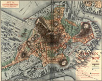
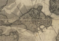
| Boston Shawmut Peninsula Maps |
| • |
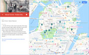
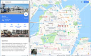
Boston (Shawmut Penninsula) - Google Maps, Terrain |
| • |
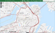
Boston (Shawmut Penninsula) - MassMapper MassGIS |
| • |
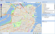
Boston (Shawmut Penninsula) - USGS - The National Map |
| • |
Boston South Quadrangle - 2018 (60 MB PDF) - USGS Topo Download |
| • |
The Town of Boston in New England, John Bonner, 1722 - Massachusetts Historical Society |
| • |
A Plan of Boston in New England with its Environs, Henry Pelham, 1777 - Library of Congress |
| • |
Putting Boston on the Map: Land Reclamation and the Growth of a City - Library of Congress |
| • |
A Plan of the Town of Boston with the Intrenchments & Ca. of His Majesty's Forces in 1775, Thomas Hyde Page, 1777 - Wikipedia |
| • |
Map of the City of Boston, Mass., Matthew Dripps, 1852 - Norman B. Leventhal Map Center, Boston Public Library |
| • |
Boston, 1630 to 1675, George E. Waring, Jr., United States. Census Office - University of Texas |
| • |
Historical Maps of Boston and Environs - Charles River Alliance of Boaterss |
| • |
Boston: History of Landfills, Jeffery Howe - Boston College |
| • |
List of Maps of Boston Published Between 1600 and 1903, Boston Engineering Dept, 1903 - Google ebook |
| • |
MapJunction |
|
|
| Boston Shawmut Peninsula Sources |
| • |
A History of Boston: The Metropolis of Massachusetts, from Its Origin to the Present Period, Caleb H. Snow, 1828 - Internet Archive |
| • |
A Topographical and Historical Description of Boston, Nathaniel B. Shurtleff, 1871 - Internet Archive |
| • |
The Memorial History of Boston including Suffolk County, Massachusetts, 1630-1880, Justin Winsor, 1881, Vol. 1, Vol. 2, Vol. 3, Vol. 4. - Internet Archive |
| • |
Sentry, or, Beacon Hill: the Beacon and the Monument of 1635, William W. Wheildon, 1877 - HathiTrust |
| • |
Illustrated Boston, the Metropolis of New England, American Publishing and Engraving Co., 1889 - Google ebook |
| • |
Boston Common: Scenes From Four Centuries, Mark A. De Wolfe, 1910 - Internet Archive |
| • |
Boston of To-day: A Glance at Its History and Characteristics, Edwin M. Bacon, 1892 - Google ebook |
| • |
Old Landmarks and Historic Personages of Boston, Samuel A. Drake, 1900 - Internet Archive |
|
|
|