| Hills of Arlington, Mass. |
| | Hills | More about Arlington's USGS-listed hills | Maps | Sources | |
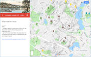
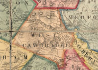
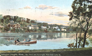
| Arlington Heights Hills |
| • |
USGS identified - MassMapper MassGIS |
| • |
Google Maps | Google Earth - Google |
| • |
"...The western part of the town is hilly, Arlington Heights and Turkey Hill being the most prominent elevations, while the eastern end is level...", Hurd, pg. 173, 1890 - Internet Archive |
| • |
Earlier name: "...Arlington Heights, formerly known as Circle Hill, has always been noted for fine scenery, and for the magnificent views, from the summit of the hill, of the city and harbor of Boston, and the numerous towns
and cities adjoining...", Cutter, pg. 163, 1880 - Internet Archive |
| • |
Earlier names: "...and that part of the once-named Welsh Mountains which has successively borne the name of Circle Hill, Peirce's Hill, and Arlington Heights...", Arlington 100th Anniv., pg. 34, 1907 - Internet Archive |
| • |
Earlier name: "...The first new section to be opened on an extensive scale for building purposes, was what was "Pierce Hill," now called Arlington Heights. In 1872 an association of gentlemen doing business in Boston bought the farms located on this property owned almost wholly by descendants of Jonas Pierce, eldest son of Capt. Solomon Pierce of Revolutionary fame, with whom the old veteran had a home until his death in October, 1821... ...", Parker, pg. 85, 1907 - Internet Archive |
| • |
"...The Reverend Nathan Appleton, a Boston prelate who was a member of one of the farming families, is said to have spent his summers in a "mansion house" near the Heights' highest point, 377 feet above sea level. Here he planted a circle of Lombardy trees and erected a flagpole...", Arlington Multiple Resource Area (PDF) - National Park Service |
| • |
Solomon Peirce Family Genealogy, Marietta P. Bailey, 1912 - Internet Archive |
| • |
Peirce Farm Historic District, "..The Peirce Farm area of Arlington Heights was settled originally in the 1830s by three members of the Peirce Family. The three - Thomas Peirce, John A.P. Peirce, and J. Peirce - were among the first to sttle the rocky, thickly wooded highlands of western Arlington... ", Massachusetts Cultural Resource Information System (MACRIS) |
| • |
Arlington Heights Hills - USGS Geographic Names Information System |
|
| Crescent Hill |
|
| Hills Hill |
| • |
Google Maps | Google Earth - Google |
| • |
Hills Hill Park, List of Parks - Town of Arlington |
| • |
"....Minute directions are inscribed on the records in 1689 for the division of a large tract which apparently covers the greater part of the present town of Arlington. This region was called by the general name of the Cambridge Rocks...the 68th lot was laid out to Jacob Hill. It contained eight acres....", Parker, pg. 27, 1907 - Internet Archive |
| • |
"...Isaac Hill was born of poor but respectable parentage. His father also named Isaac, is a native of the present town of West Cambridge, then a part of Cambridge Mass., and known as the parish of Menotomy.... ", Biography of Isaac Hill, of New Hampshire, Cyrus P. Bradley, pg. 5, 1835 - Google ebooks |
|
| Menotomy Rocks |
| • |
Google Maps | Google Earth - Google |
| • |
"...An illustration of the force of the glacier is discovered in that weird section of Menotomy Rocks Park known now as always within the memory of any here as 'Devil's Den'.... ", Parker, pg. 90, 1907 - Internet Archive |
| • |
"...Originally referred to as “The Devil’s Den,” Menotomy Rocks Park was established in 1896 during an era when the importance of recreational woods and park lands was supported as part of major public planning initiatives at the local, regional, and state level...", (PDF), pg. 27 - Menotomy Minuteman Historical Trail |
| • |
"...Granite is an felsic and phaneritic rock. This means that the rock is coarse-grained and formed inside the chamber of a volcano, where it cooled slowly. This is granite found in Menotamy Rocks Park....", Menotamy Rocks - Boston Basin Geology |
|
| Mount Gilboa |
| • |
USGS identified -MassMapper MassGIS |
| • |
Google Maps | Google Earth - Google |
| • |
"...Mount Gilboa Conservation Area. This ten-acre conservation site in northwest Arlington is a steep, tree-covered hill with one house, large rock outcroppings, and a network of woodland trails. ...", Arlington Master Plan, Working Paper Series: Natural Resources and Open Space, pg. 12 (PDF) - Town of Arlington |
| • |
"...Mount Gilboa, a scriptural name now seemingly lost. ...", Arlington 100th Anniv., pg. 34 (PDF), 1907 - Internet Archive |
| • |
Likely reference to Biblical Mount Gilboa - Wikipedia |
| • |
Mount Gilboa - USGS Geographic Names Information System |
|
| Robinson Rock |
|
| Symmes Hill |
| • |
Google Maps | Google Earth - Google |
| • |
Stephen Symmes, Jr. House, "...At his death in 1901, Stephen Symmes, Jr., donated his farm to the town to
be used as a hospital site. The city fathers sold the house instead -- to the
Fairchild family -- and the hospital was erected on its present site, using the
proceeds from the sale of the house..." - Massachusetts Cultural Resource Information System (MACRIS) |
| • |
"...Arlington’s highest elevation, Turkey Hill (380 feet), along with Mount Gilboa and Symmes Hill, are all located in this part of town. ...", Arlington Master Plan, Working Paper Series: Natural Resources and Open Space, pg. 1 (PDF) - Town of Arlington |
|
| Turkey Hill |
| • |
USGS identified -MassMapper MassGIS |
| • |
Google Maps | Google Earth - Google |
| • |
"...Turkey Hill, with its twin pines, long a landmark of the mariner sailing into Boston Harbor. ...", Arlington 100th Anniv., pg. 34, 1907 - Internet Archive |
| • |
"...The western part of the town is hilly, Arlington Heights and Turkey Hill being the most prominent elevations, while the eastern end is level...", Hurd, pg. 173 - Internet Archive |
| • |
"...Two high prominences, Arlington Heights and Turkey Hill, mark the beginning of the Fells Upland and lie on either side of the river. ...", Arlington Master Plan, Working Paper Series: Natural Resources and Open Space, pg. 1 (PDF) - Town of Arlington |
| • |
"...Meleagris gallopavo silvestris (Vieill.) Wild Turkey - Turkey Hill in Arlington may well have derived its name from the presence there of this noble bird in early Colonial days. Indeed Mr. Walter Faxon writes me that an acquaintance of his has seen 'in a manuscript diary of the ancestor of an Arlington man... an entry of killing some Wild Turkeys in the region about Turkey Hill.' ...", The Birds of the Cambridge Region of Massachusetts, pg. 175, William Brewster, 1906 - Google ebook |
| • |
History of Arlington Street Names: ‘Turkey Hill Terrace’, "...Turkey Hill is one of the highest points in Arlington, 351 feet in elevation. Its name pre-dates the creation of the subdivision, originating in the reputation of its woods as a breeding ground for wild turkeys. ...", Richard A. Duffy, 2010 - Wicked Local |
| • |
Turkey Hill - USGS Geographic Names Information System |
|
|
|
 |
|
| Arlington Heights Hills |
 |
|
| Crescent Hill |
 |
|
| Mount Gilboa |
 |
|
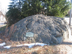
| Robinson Rock |
 |
|
|
|
| More about Arlington's USGS-listed hills |
|
Located primarily on the rocky north-west borders of the Boston Basin, present-day Arlington, Mass. was called Menotomy, an Algonquian word meaning "swift running water”, and later Cambridge Rocks. Most of town falls within the borders of early Cambridge, Mass., an area that extended from Brighton to Lexington. In 1807, it became the separate town of West Cambridge, then in 1867 changed its name to Arlington to honor those buried in the Arlington National Cemetery. Arlington has three hills listed by the USGS, Arlington Heights Hills (282 ft.), Mount Gilboa (312 ft.), and Turkey Hill (351 ft.). The Turkey Hill name is common, there are three with that name in the Boston Basin area, and ten in Massachusetts. What is uncommon is finding confirmation of turkeys on the hill. William Brewster in his 1906 book on The Birds of the Cambridge Region, writes that "an acquaintance of his has seen 'in a manuscript diary of the ancestor of an Arlington man... an entry of killing some Wild Turkeys in the region about Turkey Hill.'" 1 |
| Mount Gilboa is a name from the Bible. Arlington Heights was given its name in 1872 by developers who had purchased land which previously had been known as Peirce’s Hill. Descendants of Revolutionary War hero Capt. Solomon Peirce2 had purchased all the land in the area in 1803.3 Included in the purchase was the summer home of Revered Nathaniel Appleton. He had planted a circle of Lombardy trees there leading to the hill being given the name, Circle Hill.4 |
| Other hills in Arlington include the uniquely named Hills Hill. Members of the Hill family were in the area as early as 1689, when Jacob Hill received land in Cambridge Rocks.5 Built on a spur of Mount Gilboa, Crescent Hill could probably fall into the category of a neighborhood. Menotomy Rocks preserves the original Native American name for the area. Robinson Rock and Symmes Hill maintain the names of prominent citizens of the town. |
|
|
| Arlington Maps |
| • |
Arlington - Google Maps, Terrain |
| • |
Arlington - MassMapper MassGIS |
| • |
Belmont - Mapjunction |
| • |
Lexington Quadrangle - 2018 (60 MB PDF) - USGS TopoView Download | All USGS maps |
| • |
Menotomy Maps: 1650, 1700, 1750, 1800 - Robbins Library - Digital Commonwealth |
| • |
Arlington Maps: 18, 19, 20, Atlas of Middlesex County, Volume 1, published by Geo. W. Stadly & Co., 1900 - State Library of Massachusetts |
|
|
| Arlington Sources |
| • |
History of the town of Arlington, Massachusetts, Benjamin Cutter, 1880 - Internet Archive |
| • |
The One Hundredth Anniversary of the Incorporation of the Town of Arlington, Massachusetts, 1907 - Internet Archive |
| • |
Town of Arlington, Past and Present: A Narrative of Larger Events and Important Changes in the Village Precinct and Town from 1637 to 1907, Charles S. Parker, 1907 - Internet Archive |
| • |
Arlington, History of Middlesex County, Massachusetts, with Biographical Sketches of Many of its Pioneers and Prominent Men, Duane Hurd, 1890 - Internet Archive |
| • |
Arlington, History of Middlesex County, Massachusetts: Containing Carefully Prepared Histories of Every City and Town in the County, Samuel A. Drake, Vol. 1, 1880 - Internet Archive |
| • |
Arlington: Images of America, Richard A. Duffy, 1997 - Google ebook preview |
| • |
Arlington, MHC Reconnaissance Survey Town Report (PDF), 1980 - Massachusetts Historical Commission |
| • |
Arlington Multiple Resource Area (PDF), National Register of Historic Places, 1985 - National Park Service |
| • |
Atlas of the Boundaries of the Town of Arlington, Middlesex County, 1901 - State Library of Massachusetts |
| • |
What’s in a name? Ask Richard Duffy, - Richard A. Duffy - Wicked Local |
|
|
| Footnotes |
| 1 |
The Birds of the Cambridge Region of Massachusetts, pg. 175, William Baker, 1906 - Google ebook |
| 2 |
A Brief History Of Patriot Solomon Peirce, Bruce J. Leader - The Lexington Minuteman Men |
| 3 |
Parker, pg. 85, 1907 - Internet Archive |
| 4 |
Arlington Multiple Resource Area, pg. 4 (PDF), National Register of Historic Places, 1985 - National Park Service |
| 5 |
Parker, pg. 28, 1907 - Internet Archive |
|
|