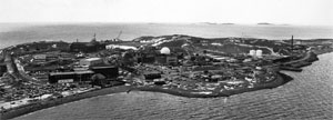
| Although still an island by name, Deer Island has been connected to the mainland since the former Shirley Gut channel, which once separated the island from the town of Winthrop, was filled in by the 1938 New England hurricane. All of the original hills on the Island were moved or removed duing the construction of the sewage treatment there. |
|
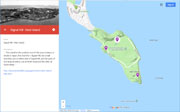
| Hills of Deer Island - Boston, Mass. |
| Money Hill (Historic) |
|
| Signal Hill (North and South Heads) (Historic) |
| • |
Google Maps | Google Earth - Google |
| • |
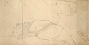
"...It has two hills and four bluffs, which are known by the following names: North Head, East Head, and South Head (or Money Head), situated as the names indicate, Graveyard Bluff, a small projection on the southwesterly part of the island, and Signal Hill in the central part. The small elevation at the northerly part of the island, where the old house of Major Ebenezer Thayer used to stand, has nev er been dignified by any special appellative. The South Head took the name of Money Head in consequence of the money-digging affair that occurred there some years ago....", Shurtleff, pg. 463, 1871 - Hathitrust |
| • |
"...it was early named Deer Island because 'of the Deare which often swimme thither from the Maine when they are chased by Woolves' (William Wood, 1634)...", Bacon, pg. 152, 1883 Google ebook |
| • |
"...This island at the southern end of the area contains, in whole or inpart, five drumlins -- Signal Hill, two small drumlins, one on either side of Signal Hill, and the parts of two large drumlins, one at North Head and the other at South Head...", Roorbach, pg. 47, 1910 - Hathitrust |
| • |
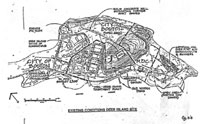
"...Deer Island has recently undergone extensive regrading and
topographical change including the filling of Cow Pond on the
north side of Signal Hill which has been cut down, altering the original setting of the prison complex...", Deer Island House of Correction, Historic American Buildings Survey - Library of Congress |
| • |
"...Before construction could begin, a glacial drumlin (large hill) in the center of Deer Island was relocated to form a barrier between the adjacent community of Winthrop and the construction and operation of the new treatment plant...", The Deer Island Sewage Treatment Plant - Massachusetts Water Resources Authority |
| • |
Fort Dawes, "...Fort Dawes, formerly located on Deer Island, is sort of the "dissappearing man" of Boston's harbor defenses. Once the largest fort in the Boston system (at 100 acres), Fort Dawes began as a command and fire control center..." - CoastDefense.com |
|
| Whortleberry Hill (Historic) |
|
|
|
|
|
| Deer Island Sources |
| • |
Deer Island, Chapter 36, Nathaniel B. Shurtleff, A Topographical and Historical Description of Boston, 1871 - Hathitrust |
| • |
Shoreline Changes in the Winthrop Area, Massachusetts, George B. Roorbach, Bulletin of the Geographical Society of Philadelphia, Vol. 8, 1910 - Hathitrust |
| • |
Deer Island, King's Dictionary of Boston, Edwin Monroe Bacon, 1883 Google ebook |
| • |
Deer Island: A History of Human Tragedy Remembered - Indian Country Today |
| • |
History: Deer Island, MWRA, 1999 - Internet Archive |
| • |
Deer Island Prison, Ten O'Clock News, 1977 - Boston TV News |
| • |
Deer Island - National Park Service |
| • |
Deer Island - Clio |
| • |
Fort Dawes - CoastDefense.com |
| • |
Deer Island Farm House - Massachusetts Historical Commission Information System (MACRIS) |
| • |
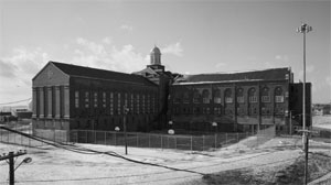
Deer Island House of Correction, Historic American Buildings Survey - Library of Congress |
| • |
The Deer Island Sewage Treatment Plant - Massachusetts Water Resources Authority |
|
|
|