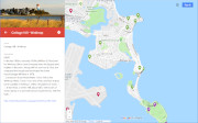
| Hills of Winthrop, Mass. |
| | Hills | More about Winthrop's USGS-listed hills | Maps | Sources | |
| Chelsea Point |
|
| Cottage Hill |
| • |
USGS identified - MassMapper MassGIS |
| • |
Google Maps | Google Earth - Google |
| • |
Cottage Hill - Hillside Avenue, "...During the mid-19th century Cottage Hill was known as Green Hill..." - Massachusetts Historical Commission Information System (MACRIS) |
| • |
"...And so we come "up along" to Great Head or Cottage Hill which was bought and laid out into streets and lots by Wm. B. Rice, H.T. Whitman, et al, in the year 1883..", Howard, 1950 - Winthrop Public Library |
| • |
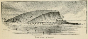
"...Cottage Hill, sometimes called Great Head or Green Hill, is the highest promontory in town. It rises to a height of 105 feet above the surf which pounds below it, and is the favorite lookout for residents of the town..", Snow, pg. 6, 1939 - Winthrop Public Library |
| • |
Winthrop, Massachusetts, "..Located on Great Head (Water Tower Hill) is the Winthrop Water Tower. It is a red, white, and blue striped tower capable of holding 1 million US gallons of water..." - Wikipedia |
| • |
"...Great Head, or Green Hill, about half a mile south of Ocean Spray, is a symmetrical curving eminence, 100 feet high, from whose summit very extensive views are given over the adjacent bays and shores, and out on the open sea....", Sweetser, pg. 137, 1888 - Winthrop Public Library |
| • |
Cottage Hill - USGS Geographic Names Information System |
|
| Deer Island |
|
| Devils Rock |
|
| Floyds Hill |
| • |
Google Maps | Google Earth - Google |
| • |
"..Almont, Locust, and Cross Streets were laid out on "Floyd's Hill" (land owned by Deacon David Floyd (1807-1895)) in 1875. The Floyd family connection to the Winthrop area dates back to Captain John Floyd (1638-1702)..", Howard, 1950 - Winthrop Public Library |
| • |
"..In 1875 the southern side of Floyd Hill, was surveyed for building lots...The area was called Floydonia since a number of Floyd families lived along Revere Street and on the hill crested by Summit Avenue..", Sesquicentennial Commemorative Book, 2002 - Winthrop Public Library |
| • |
"..The present eastern one extends in a double, or S-shaped, curve from Winthrop Head to Residence Hill, convex toward the ocean at its southern half and concave at the northern half..", Roorbach, pg. 49, 1910 - HathiTrust |
|
| Grovers Cliff |
| • |
USGS identified - MassMapper MassGIS |
| • |
Google Maps | Google Earth - Google |
| • |
"...A continuous cliff extends from the northern end of Winthrop Beach around the projecting headland called Grover's Cliff...", Roorbach, pg. 49, 1910 - HathiTrust |
| • |
Grovers Ave., "...Jotham Grover (1659-?) was the son-in-law of Deane Winthrop. Jotham married Margaret Winthrop (1660-1695)..", Winthrop, Mass. Our Streets, How we got them and their names, Channing Howard, 1950 - Winthrop Public Library |
| • |
"..the two hills of the Highlands section of Winthrop were originally part of the 1636/1637 allotments..", Sesquicentennial Commemorative Book, 2002 - Winthrop Public Library |
| • |
Fort Heath, "..the first concrete foundation for one of the disappearing guns at Grovers Cliff was complete in May 1898, and in 1900 the installation was renamed Fort Heath..." - Wikipedia |
| • |
"..The Fort Heath drumlin, which terminates to the east as Grover's Cliff, consists mainly of unmodified till or boulder clay which was deposited directly by the glacier..", Triantafell, pg. 7, 1952 - Boston University |
| • |
Grovers Cliff (Cliff) - USGS Geographic Names Information System
Variant: King's Cove |
|
| Ingalls Hill |
|
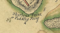
| Point Shirley |
| • |
USGS identified - MassMapper MassGIS |
| • |
Google Maps | Google Earth - Google |
| • |
"...At the other end of the town. Point Shirley Hill once stood 55 feet high, but twelve feet were removed from its summit in 1907...", Snow, pg. 6, 1939 - Winthrop Public Library |
| • |
"...Point Shirley, north of Shirley Gut, is made up of a small drumlin, Point Shirley Hill, and a plain of sand and gravel formed by beaches and spits which nearly surround it...", Roorbach, pg. 49, 1910 - HathiTrust |
| • |
Point Shirley, "...Pt. Shirley...was of course named for our Royal Governor, Wm. Shirley who, in 1753, came down the Harbor with a number of Boston's leading citizens to establish here a fishing plant - which was the practical beginning of the interesting history of this interesting peninsula - the farthest of Boston's extensions into the sea (but since 1739 having been set off as Chelsea)..", Winthrop, Mass. Our Streets, How we got them and their names, Channing Howard, 1950 - Winthrop Public Library |
| • |
Point Shirley (Cape) - USGS Geographic Names Information System
Variant: Pullen Poynte |
|
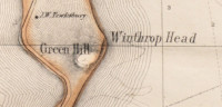
| Winthrop Head |
| • |
USGS identified - MassMapper MassGIS |
| • |
Google Maps | Google Earth - Google |
| • |
"..Winthrop Head - Nearly one-half of this drumlin has been eroded by the waves, the remaining half terminating in a cliff over loo feet in height..", Roorbach, pg. 49, 1910 - HathiTrust |
| • |
"...on the north side of Winthrop's Great Head or Green's Hill, so called, and including also the whole of said hill...", Acts and Resolves Passed by the General Court of Massachusetts, pg. 138, 1846 - HathiTrust |
| • |
"..Winthrop Beach curves between the the headlands, Grover's Cliff and Great Head..", Triantafell, pg. 67, 1952 - Boston University |
| • |
Winthrop Head (Cliff) - USGS Geographic Names Information System
Variant name: Great Head |
|
| Winthrop Highlands |
| • |
Google Maps | Google Earth - Google |
| • |
"...The area known as the Highlands is really a double hill, rising at its highest point to a level 82 feet above the sea..", Snow, pg. 6, 1939 - Winthrop Public Library |
| • |
"..the two hills of the Highlands section of Winthrop were originally part of the 1636/1637 allotments..", Sesquicentennial Commemorative Book, 2002 - Winthrop Public Library |
| • |
"..Winthrop's hills are all drumlins... and the four hills at the Winthrop's hills are all drumlins... and the four hills at the Highlands..", Clark, pg. 6, 1952 - Winthrop Public Library |
| • |
"..The principle drumlins of Winthrop and their elevations are Great Head (l02 feet), Point Shirley (53 feet), Fort Heath
(72 feet), Summit Avenue (84 feet), and Upland Road (91 feet)..", Triantafell, pg. 6, 1952 - Boston University |
| • |
"..Mount Fairview, the loftiest summit of Winthrop Highlands, is hill in Winthrop which affords most comprehensive view of Boston region a prospect unequalled on the whole North Shore..", Cobb, pg. 658, 1898 - Google ebook |
|
|
|
 |
|
 |
|
| Chelsea Point |
 |
|
| Cottage Hill |
 |
|
| Devils Rock |
 |
|
| Grovers Cliff |
 |
|
| Point Shirley |
 |
|
 |
|
| Winthrop Head |
 |
|
 |
|
 |
|
|
|
| More about Winthrop's USGS-listed hills |
|
The early name Europeans gave to Winthrop was Pulling Point. It refers to what sailors, depending on the wind and tide, would be required to do to get their boats through the narrow channel between the point and Deer Island (it named for deer that would flee to the island to escapes wolves). The name “Pullen Poynte” appears in Massachusetts Bay Colony records in 1630, the same year John Winthrop and his fleet of Puritans arrived. In September of that year while travelling by boat from Plymouth to Boston, William Bateman feeling sick and weak was put ashore with provisions on land near “Pullen Poynte.” Returning two days later, his companions found him dead. The jury found no blame for the companions, instead finding that Bateman had died by “Gods visitacon” (visitation).1 |
|
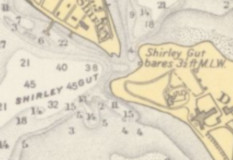
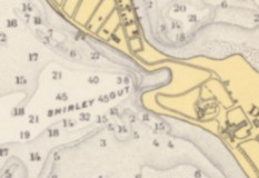
Like other coastal towns Winthrop has hill-like features listed by the USGS. This including two Capes and two Cliffs. Point Shirley (10 ft., Cape) is named for William Shirley (1694-1771), a pre-Revolutionary War governor of Massachusetts. In the mid-1700s a group of Boston businessmen bought the southernmost portion of Pulling Point for a cod fishing station.2 Governor Shirley was invited to the opening of the facility, and the point was renamed in his honor. The operation didn’t last long, and later the area would see a salt works open, and after that a Revere copper works.3
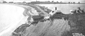
That would also close and be replaced by summer cottages. That was a trend that had started with the cod fishing station. John Hancock was one of the investors and he built a cottage that still stands today. Shirley Gut, as it came to be called, was never very deep. Nautical charts from the mid-1800s show a MLW (mean low water) depth of 5 feet. In 1936 the NOAA chart shows the gut still open, but with a warning that it “bares at low tide.” The 1939 chart shows the gut closed and a road passing over it to Deer Island. The gut had seen some history. During the Revolutionary War, James Mugford, commanding the schooner Franklin in the Continental Navy, captured a British ship with vital supplies.4 After returning to his ship he had grounded at Pulling Point, he was attacked by multiple British boats. Fighting off the attackers, he would be the sole colonial casualty. In the War of 1812, there are unsubstantiated reports that the USS Constitution used Shirley Gut to evade a British blockade. |
|
Pulling Point was originally part of an area called Winnisimmet (Native American and thought to mean “at the good spring”). The area was annexed by Boston in 1634. In 1739, what is now Chelsea, Revere, and Winthrop, split off from Boston and became the Town of Chelsea. Winthrop succeeded from Chelsea and incorporated as a town in 1852. Most say the town is named for John Winthrop (1588-1649), second governor of the Massachusetts Bay Colony and an English Puritan leader. He was granted a large amount of land on Pulling Point, but likely never permanently resided in the town. His estate named Ten Hills was on the Mystic River in today’s Somerville. The land on Pulling Point was inherited by his youngest son Deane Winthrop (1623-1704). Deane was involved in the settlement of Groton, Mass, but his permanent residence was on Pulling Point. The house he lived still stands, and some say the town is named for him. |
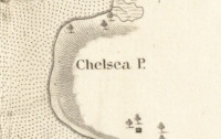
| The name Chelsea Point (13 ft., Cape) was sometimes used to describe all of Winthrop except for Point Shirley. The USGS identifies Chelsea Point as the cape facing west looking out, until the late 1940s, over the Noddle Island mud flats. Now filled, today part of Logan Airport is in the town of Winthrop. The name Chelsea Point is also used for the bridge built in 1839 that connected what was then Chelsea Point to East Boston. Like other areas around the edges of the Boston Basin, more convenient access to the city encouraged development and, initially, attracted wealthy Bostonians able to buy land and build luxurious country estates. The two most prominent Bostonians attracted to the area in the late 1840s were Edward G. Loring (1802-1890) and George B. Emerson (1797-1881).5 Loring was the Massachusetts judge widely reviled for ordering two escaped slaves be sent back to slavery under Fugitive Slave Law of 1850. Emerson was an education reformer and botanist who played a key role in the established of the Arnold Arboretum. Both estates were built on Chelsea Point. |
|
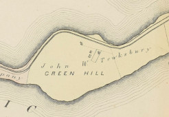
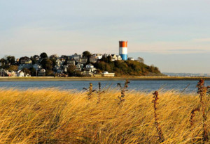
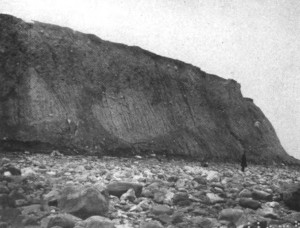
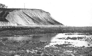
USGS-listed Winthrop Head (82 ft., Cliff) is the eroded face of USGS-listed Cottage Hill (95 ft.). The hill was part of the original allotment of land John Winthrop received in 1640. As per conditions of the grant, he built a house on the land next to the hill. It is thought that his son Deane Winthrop lived there before moving into the house that now bears his name. A hill was mentioned in the grant but it wasn’t named.6 A name, or names, for the hill appear in an 1846 Massachusetts General Court record giving an indemnification of $500 to William Tewksbury for losses he suffered by for being, “unnecessarily debarred from the use of his land” that is identified as running from “Winthrop’s Great Head or Green’s Hill” to Pulling Point. Interesting that the official record calls the town Winthrop in 1846 even though the town would not be incorporated with that name until 1852. The origin of the name Green’s Hill is obscure. An 1856 H.F. Walling map of Boston and its Vicinity labels it Green Hill. As does the 1874 G.M. Hopkins Atlas of Suffolk County. That map shows one building on the hill owned by another Tewksbury, John W. Tewksbury. Since the early 1700s generations of Tewksbury’s have held prominent positions in the town. There is no record of anyone named Green living on the hill or having an important position in the town. By the time the 1896 G.W. Bromley Atlas of Chelsea, Revere, Winthrop is published the hill called Great Head and shown fully subdivided with streets with numerous buildings on them. Though there still is a Green Hill Path pedestrian walkway down the southern side of the hill. Constructed when the hill was first developed, it provided a shortcut for people walking to the train. The name Cottage Hill only came into use in the mid-1800s when real estate developers anxious to promote the area thought it would be more attractive to prospective buyers. Today the hill is still often called Great Heads, and also Water Tower Hill, named for the steel standpipe built on the summit in 1910. |
|
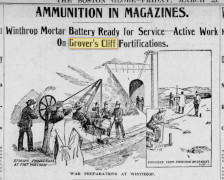
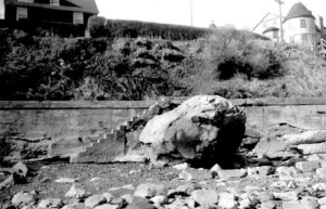
USGS-listed Grovers Cliff (0 ft., Cliff) is named for Jotham Grover (1659-), the husband of Margaret Winthrop (1660-1695), one of Deane Winthrop’s daughters. Like Winthrop Head, Grovers Cliff is the face of a hill eroded by the ocean. Unlike Winthrop Head the Hill is unnamed. The area is called Winthrop Highlands and contains a taller, less eroded hill that has been referred to as Mount Fairview and Prospect Hill. The USGS topographic map shows Grovers Cliff with an elevation of 60 ft., and its companion hill at 90 ft. The area, purchased by Deane Winthrop, remained in family hands for two generations, then went through a succession of ownership by noted Boston families before becoming the property again of the Winthrop family when it was inherited by Elizabeth Bowdoin Temple Winthrop (1769-1825). The Highlands was bought by City of Boston in 1868 with the idea that it would be a good location for a “lunatic hospital” for the insane. The site was ultimately considered not suitable and land was sold to industrialist William B. Rice, the same man who bought Winthrop Head. The land directly above Grovers Cliff was sold to the military where they built Fort Heath in 1898. The rest of the Highlands was subdivided for development. The name Grovers Cliff appears on an 1852 Map of Boston Harbor E.S. Chesbrough map. |
|
|
| Winthrop Maps |
| • |
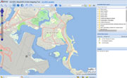
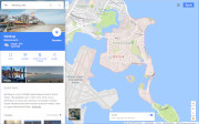
Winthrop - Google Maps, Terrain |
| • |
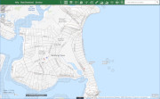
Winthrop - MassMapper MassGIS |
| • |
Winthrop - USGS - The National Map |
| • |
Hull Quadrangle - 2018 (40 MB PDF) - USGS Topo Download |
| • |
Lynn Quadrangle - 2018 (40 MB PDF) - USGS Topo Download |
| • |
Winthrop, Atlas of the County of Suffolk, Mass., Vol. 4, Including East Boston, Chelsea, Revere, and Winthrop, G.M. Hopkins, 1874 - State Library of Massachusetts |
| • |
Winthrop Maps: 26, 27, 28, 29, 30, 31, 32, Atlas of The City of Chelsea and the Towns of Revere & Winthrop, G.W. Bromley & Co., 1914 - State Library of Massachusetts |
| • |
Atlas of the boundaries of the town of Winthrop, Suffolk County, 1898 - State Library of Massachusetts |
|
|
| Winthrop Sources |
| • |
A Documentary History of Chelsea: including the Boston Precincts of Winnisimmet, Rumney Marsh, and Pullen Point, 1624-1824, Vol. 1, Vol. 2, Mellen Chamberlain, 1908 - Internet Archive |
| • |
Winthrop, King's Handbook of Boston Harbor, Moses F. Sweetser, 1888 - Internet Archive |
| • |
The Town of Winthrop, Albert W. Cobb, New England Magazine, Vol. 6, pg. 645, 1892 - Google ebook |
| • |
Winthrop Days, And A Half Century With The Trees - 1855-1905, Mary P. Griffin, 1905 - Winthrop Public Library |
| • |
Shoreline Changes in the Winthrop Area, Massachusetts, George B. Roorbach, Bulletin of the Geographical Society of Philadelphia, Vol. 8, 1910 - Hathitrust |
| • |
A History of Winthrop, Massachusetts, Edward R. Rowe, 1939 - Boston University |
| • |
Winthrop, Mass. Our Streets, How we got them and their Names, Channing Howard, 1950 - Winthrop Public Library |
| • |
The History of Winthrop, Masachusetts, 1630-1952, William H. Clark, 1952 - Winthrop Public Library |
| • |
The Geography of Winthrop, Massachusetts, Arthur N. Triantafell, 1953 - Boston University |
| • |
Historic Winthrop 1630-1902, Charles W. Hall, 1902 - Hathitrust |
| • |
Winthrop, Images of America, Winthrop Historical Commission, 2002 - Google ebook preview |
| • |
Town of Winthrop Sesquicentennial Commemorative Book - 1852-2002, 2002 - Winthrop Public Library |
| • |
Town of Winthrop Open Space and Recreation Plan (PDF) - Town of Winthrop |
| • |
Winthrop, MHC Reconnaissance Survey Town Report (PDF), 1981 - Massachusetts Historical Commission |
|
|
| Footnotes |
| 1 |
Vpon vew of the dead Body of Willm Bateman, September 18th, 1630, Records of Massachusetts, Vol. 1, 1628-1641, pg. 78, 1853 - Internet Archive |
|
New Englands Prospect, William Wood, pg. 42, 1634 - HathiTrust |
| 2 |
Point Shirley, Chamberlain, Vol. 1, pg. 391, 1908 - Internet Archive |
| 3 |
John Hancock House - MACRIS, Massachusetts Historical Commission |
|
Samuel Sturgis House - MACRIS, Massachusetts Historical Commission |
|
The Point Shirley Copper Works, T. Egleston, The School of Mines Quarterly, October , 1885 - HathiTrust |
| 4 |
Captain James Mugford, Jr., Continental Navy - Winthrop Town Memorials |
| 5 |
Court Park - MACRIS, Massachusetts Historical Commission |
| 6 |
Allotments of Land, Chamberlain, Vol. 1, pg. 120, 1908 - Internet Archive |
|
|