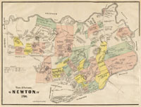
| Hills of Newton, Mass. |
| | Hills | More about Newton's USGS-listed hills | Maps | Sources | |
| Seven Hill of Newton |
| • |
"...The general features of Newton are not without interest. Seven principal elevations mark its siu-face, like the seven hills of ancient Rome, with the difference that the seven hills of Newton are much more distinct than the seven hills of Rome; - Nonantum Hill, Waban Hill, Chestnut Hill, Bald Pate, Oak Hill, Institution Hill and Mount Ida.....", Smith, pg. 13, 1880 - Internet Archive |
|
|
| Auburndale Kame |
|
| Bald Pate Hill |
| • |
USGS identified - MassMapper MassGIS |
| • |
Google Maps | Google Earth - Google |
| • |
"...Baldpate in Newton, with its curious round skull-like top showing through the trees, almost covering it, appears in clear outline. Close to the outer edge of the ledge are a
huge birch and a great pine...", Bacon, pg. 298, 1898 - Internet Archive |
| • |
"...the shaggy Bald Pate, whose heavy crowning forests make a chevelure which belies its title. This noble eminence reaches an altitude of 318 feet, and is the highest of the many hills of Newton...", Sweetster, pg. 321, 1889 - Internet Archive |
| • |
Baldpate Hill Road Area, "...Occupying the highest elevation (315 feet) in Newton, Baldpate Hill Road encompasses perhaps the largest concentration of architect-designed custom homes from the 1940-1960 period in the city..." - Massachusetts Historical Commission Information System (MACRIS) |
| • |
The Geology of Newton, "...From the top of Oak Hill you can look across to Bald Pate Hill (elevation 302'), another drumlin. Note the typically rounded elliptical shape of the hill...", James W. Skehan and Catherine W. Barton - City of Newton |
| • |
Bald Pate Hill - USGS Geographic Names Information System |
|
| Beacon Hill |
|
| • |
USGS identified - Oliver MassGIS Online Mapping Tool |
| • |
Google Maps | Google Earth - Google |
| • |
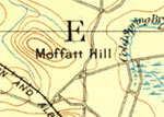
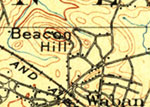
"...The hill had long been called Moffatt Hill, but with scant reason; and when the new streets were built to its summit, the name of Beacon Hill was bestowed upon it, in recognition of the fact that for a number of years the tall beacon of the United-States Coast Survey and the Massachusetts State Survey had been its most conspicuous feature....
...
As near as can be remembered, this Moffat 'squatted,' as he expressed it, on the top of the hill that bears his name. He was a very odd body, living quite by himself, with the exception of a horse, a cow, and a couple of dogs that occupied the same room in his miserable hut. Moffatt associated with no one, save when he was obliged to buy provisions or some other dire necessity...", Sweetster, pg. 242, 1889 - Internet Archive |
| • |
History and Tradition of Waban, "..I believe Moffatt Hill to be the correct name for Waban's only hill, though a more picturesque name, 'Flagstaff Hill,' was in equal vogue at that time . ...", Lawrence W. Strong - Waban Improvement Society |
| • |
William C. Strong House, "...My father, William Chamberlain Strong, was very active in securing the right-of-way for the Boston and Albany Railroad at the time the Newton Circuit Road was built...the hill was named for the squatter Moffat who resided here for many years..." - Massachusetts Historical Commission Information System (MACRIS) |
| • |
Windsor Road Historic District - Massachusetts Historical Commission Information System (MACRIS) |
| • |
"...William C. Strong, whose extensive nurseries are everywhere celebrated. Moffatt Hill, on this estate, was so called after the name of a resident on it for a brief period. When the new streets of Waban were built to its summit, the name was changed to Beacon Hill, because for several years the beacon of the United States Coast Survey and of the State Survey of Massachusetts was its most striking feature...", Hurd, pg. 19, 1890 - Internet Archive |
| • |
The Growth and Development of Newton Highlands and Waban, "...William C. Strong's new farm was 93 acres, extending from his house on Beacon Street easterly to Chestnut Street, and included Moffat Hill, a drumlin characterized by its elliptical shape and rounded peak...Strong, a well-known nurseryman, planted fruit trees on the southern slope and devoted the other, more level ground, to hardy trees, shrubs, roses and vines. He was a knowledgeable authority on raising fruit trees and wrote several publications on the subject, among them, Fruit Culture..." - Waban Improvement Society |
| • |
Culture of the Grape, William C. Strong, 1867 - Internet Archive |
| • |
Beacon Hill - USGS Geographic Names Information System
Variant name: Moffat Hill |
|
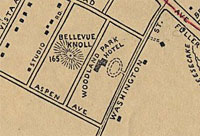
| Bellevue Knoll |
| • |
Google Maps | Google Earth - Google |
| • |
Auburndale Boating Map 1880, E.G. Chamberlain, Historic Maps of Newton - City of Newton, Massachusetts |
| • |
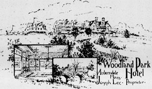
"...Less than a mile from Auburndale station, by the lovely Woodland Avenue, and about half a mile from Woodland station, on the Circuit Railway, is the chief public house of Newton, the Woodland-Park Hotel, well-secluded from the adjacent rural roads, and standing on an elevated plain, with a charming view of the far-away Blue Hills of Milton...The first lessee and present proprietor of the house is Joseph Lee, a Virginian, sometime a butler in the United-States Navy, who has won a renown extending over four counties, for the ingenious excellence and variety of his cookery...", Sweetster, pg. 206 , 1889 - Internet Archive |
| • |
Joseph Lee, "...Joseph Lee was born in 1849 and lived most of his life in Boston, Massachusetts. Lee was very prominent in the food services industry, having begun working as a boy at a bakery. He soon began preparing, cooking and serving food, eventually opening two successful restaurants in the Boston area. In the late 1890s he owned and managed the Woodland Park Hotel in Newton, Massachusetts for 17 years..." - The Black Inventor |
|
| Burnt Hill |
| • |
"..[Thomas Prentice] after his own decease, his homestead at Burnt Hill in Newton...", Smith, pg. 150, 1880 - Internet Archive |
|
| Chestnut Hill |
| • |
USGS identified - MassMapper MassGIS |
| • |
Google Maps | Google Earth - Google |
| • |
Chestnut Hill, "..Named by Francis Lee, who built the first country house in the area in the 1850's, Chestnut Hill is in three different towns (Brighton, Brookline, and Newton) and two different counties (Norfolk and Middlesex)...
...True to its name, a stand of chestnut trees stretched from Dunster Street to Reservoir Lane...", Linda O. Pehlke, 2005 - Brookline Historical Society |
| • |
A Brief History of Chestnut Hill, "...Present Newton was known as "Cambridge Village" and we are located on what was called 'Cambridge Hill.' ...
...The first actual settlers of Chestnut Hill arrived in 1650 from Hingham, where they had poineered that town since 1636. Thomas Hammond, Vincent Druce, and John Parker are listed as the 9th, 10th, and 11th settlers of the town of Newton...", The Heights, Volume LV, Number 3, 16 Sept. 1974 - Boston College |
| • |
Thomas Hammond, the elder, "...At Chestnut Hill (originally called Cambridge Hill), Thomas and Elizabeth built a farm that was lived on by five generations of Hammonds..." - Early Hammond Families |
| • |
"... about the year 1855, both he and Francis L. Lee moved to this barren domain, and built houses. The otherwise bare and bleak ridge was adorned on its north slope with a grove of aged chestnut trees, and for this reason the new-comers named it Chestnut Hill. ...", Sweetster, pg. 313 , 1889 - Internet Archive |
| • |
"... Another of the pioneers of this fair land was Vincent Druce, who in 1650 bought a great expanse of woods with Thomas Hammond, and held them in common with him until 1664, when they divided them, the line running over the great hill. ...", Sweetster, pg. 320 , 1889 - Internet Archive |
| • |
Chestnut Hill Historic District - Massachusetts Historical Commission Information System (MACRIS) |
| • |
Chestnut Hill Reservoir Historic District - Massachusetts Historical Commission Information System (MACRIS) |
| • |
Old Chestnut Hill Historic District - Massachusetts Historical Commission Information System (MACRIS) |
| • |
Chestnut Hill - USGS Geographic Names Information System |
| • |
Old Chestnut Hill Historic District (Park) - USGS Geographic Names Information System |
| • |
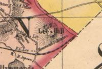
Chestnut Hill (Populated Place) - USGS Geographic Names Information System
Variant Name: Lees Hill |
|
| College Hill |
|
| Cooks Hill |
| • |
Google Maps | Google Earth - Google |
| • |
"...At a later hour, they cooked some wild game on the small conical hill standing a little east of the residence of Mr. Conant, which they named Cook Hill. Fifty or sixty years ago it was so designated ; but the name has now become obsolete...", Smith, pg. 578, 1880 - Internet Archive |
| • |
Andrew P. Conant House, "...This was the home in 1874 of Andrew P. Conant, who dealt in boots and shoes in Boston...The Websters farmed this land, and apple orchards climbed the hill . The farm waspurchased by the Fessenden School, and is stil l owned by the institution..." - Massachusetts Historical Commission Information System (MACRIS) |
|
| Crehore Hill |
| • |
Google Maps | Google Earth - Google |
| • |
Charles F. Crehore House, "...The Crehore family interests in paper-making in Newton Lower Falls began in 1825 when Lemuel Crehore, who had learned the trade in the old Milton mill, established himself in business with William Hurd. Mr. Crehore, in 1834, purchased the John Ware paper-mill of 1789 and, with partners or alone, maintained the business for twenty years..." - Massachusetts Historical Commission Information System (MACRIS) |
| • |
Ware - Crehore Paper Mill, "...One of the notable owners of this mill was Lemuel Crehore from Dorchester. Starting in 1825 with a partnership with Hurd, Crehore had numerous partners including family members and greatly expanded the business...Under various names, the Crehore Mill continued operation through the 1940s under ownership of Lemuel’s sons Charles and Fred. The mill was still producing paper in 1938..." - Massachusetts Historical Commission Information System (MACRIS) |
| • |
Auburndale Boating Map 1880, Historic Maps of Newton - City of Newton, Massachusetts |
|
| Farlow Hill |
| • |
Google Maps | Google Earth - Google |
| • |
Farlow Hill Historic District, "...The area is further distinguished by its road system which is laid out in a curvilinear pattern following the contours of Farlow Hill...
...Newton Corner businessman and philanthropist John Farlow lived on Farlow Hill during the last quarter of the nineteenth century...
...Farlow Hill is located in easternmost Newton Corner adjacent to the Boston/Brighton line. It is roughly bounded by Hood. Street and Chamberlain Road (E), Kenrick Road ( S ) , and Shorncliffe Road (NSW)...
" - Massachusetts Historical Commission Information System (MACRIS) |
| • |
Farlow Hill Historic District, "...John Farlow was a local businessman whose landscaped estate occupied 40 acres (16 ha) on Farlow Hill..." - Wikipedia |
| • |
"...In 1883-1885 an unsightly bog near Eldredge, Vernon and Church Streets was transformed into a charming park area, complete with pond and rustic bridge. It was named Farlow Park for John S. Farlow, a generous, wealthy citizen who did a great deal to improve the appearance of the village. Farlow Hill, with its many fine, unusual trees which still beautify that
area, was also developed by him...", Pre-1855 Newton houses remaining in 1976 : Newton Corner and Nonantum, pg. 5, Friends of the Jackson Homestead - Internet Archive |
| • |
"...John Smith Farlow was born in Dublin. Ireland, in January 1817, and died in Newton in 1890. In early childhood he removed to Montreal with his parents. He came to Boston in 1827 and became a citizen of the United States in 1840. About the middle of the nineteeth century he was 'a prosperous Boston merchant in the East India business and a part of his fortune was made in railroads in the pioneer day...", John Woodford Farlow, Massachusetts Historical Society Third Series, Vol. 68, Gardner Weld Allen, 1944 - JSTOR |
|
| Gray Cliff |
|
| Grove Hill |
|
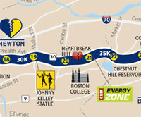
| Heartbreak Hill |
| • |
Google Maps | Google Earth - Google |
| • |
Boston Marathon Course Map - Boston Athletic Association - Internet Archive |
| • |
Boston Marathon, "...Heartbreak Hill is an ascent over 0.4-mile (600 m) between the 20- and 21-mile (32- and 34-km) marks, near Boston College..." - Wikipedia |
|
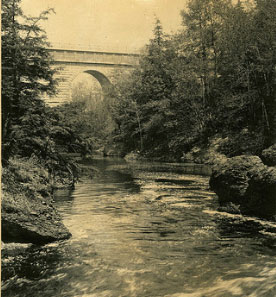
| Hemlock Gorge |
| • |
USGS identified - MassMapper MassGIS |
| • |
Google Maps | Google Earth - Google |
| • |
The Hemlock Gorge at Echo Bridge, "...This is the wild and romantic 'Hemlock Gorge,' where the stream retains much of its primitive aspect, with steep banks of conglomerate rock, clothed for the most part with a magnificent growth of hemlock, the whole forming an extraordinarily beautiful landscape feature which should be preserved intact for the enjoyment of the public forever...", Report of the Board of Metropolitan Park Commissioners, pg. 54, 1893 - HathiTrust |
| • |
Charles Eliot and the History of the Hemlock Gorge Reservation, "...'The narrow stream flows swift and dark between quaintly broken rocks, and the great stone arch which bears the Sudbury River aqueduct leaps boldly across from bank to bank' - Charles Eliot, 1893...." - The Friends of Hemlock Gorge |
| • |
Hemlock Gorge, "...Fed by the melting glacier, a more powerful Charles cut its way through layers of Roxbury puddingstone in a
geologically short 10,000 to 12,000 years, leaving this steep-walled gorge with falls at either end. The mature hemlocks & white pines that have taken hold on the river's west bank may well be the biggest trees along the entire length of the river...
" - Massachusetts Historical Commission Information System (MACRIS) |
| • |
Echo Bridge, "...The west side of the river rises to a steep hillside, heavily wooded with hemlocks while the east side is primarily open land...
" - Massachusetts Historical Commission Information System (MACRIS) |
| • |
Job #1517, Hemlock Gorge Reservation - Frederick Law Olmsted National Historic Site, National Park Service |
| • |
Hemlock Gorge (Gap) - USGS Geographic Names Information System |
|
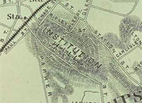
| Institution Hill |
| • |
USGS identified - MassMapper MassGIS |
| • |
Google Maps | Google Earth - Google |
| • |
Newton Theological Institution, "...Below we give a fine view of this seminary, under the patronage of the Baptist denomination...The seminary is about seven miles from Boston, in a very healthy position, beautifully situated on an elevated hill...
" - Newton Free Library, Digital Commonwealth |
| • |
Newton Theological Institution Historic District, "...The purchase included the mansion (now demolished) which had been built in 1790 atop the slope which later became known as Institution Hill..." - Massachusetts Historical Commission Information System (MACRIS) |
| • |
"...For the past 175 years the land at the top of Institution Hill has been held in good stewardship by the Andover Newton Theological School....", The Newton Conservators, 1998 - The Newton Conservators, Inc. |
| • |
Historical Address Delivered at the Fiftieth Anniversary of the Newton Theological Institution, Alvah Hoivey, 1875 - HathiTrust |
| • |
"... A fine avenue was graded at great expense from the high-road to the top of the hill, and shade-trees were planted on each side of it (now Institution Avenue).....", Smith, pg. 542, 1880 - Internet Archive |
| • |
Institution Hill - USGS Geographic Names Information System |
| • |
Newton Theological Institution Historic District (Park) - USGS Geographic Names Information System |
|
| Moffatt Hill |
|
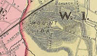
| Mount Ida |
| • |
USGS identified - MassMapper MassGIS |
| • |
Google Maps | Google Earth - Google |
| • |
"...After the Civil War it was bought by Langdon Coffin, Esq., who named it Mount Ida and laid it out in building lots...", Hurd, pg. 39, 1890 - Internet Archive |
| • |
Langdon Coffin House, "...This Mansard-roofed cottage was one of the earlier residences built on Mount Ida. The area was subdivided beginning in the Civil War period by Langdon Coffin, who apparently sold off this lot in the mid-1870's.." - Massachusetts Historical Commission Information System (MACRIS) |
| • |
"... Mount Ida is the bold hill which rises from the plain not far from the Newton station, and is covered with handsome houses and estates. In the year 1816, the entire hill was bought by John Fiske at a valuation of $3,300; and in 1850 it was held at $10,000. At the close of the Civil War, the ridge was purchased by Langdon Coffin, who bestowed upon it the name of "Mount Ida," and laid it out for habitations. There were then but three houses on it; and now the valuation of the real estate exceeds half a million dollars. ...", Sweetster, pg. 826 , 1889 - Internet Archive |
| • |
Mount Ida, "...In Greek mythology, two sacred mountains are called Mount Ida, the "Mountain of the Goddess": Mount Ida in Crete; and Mount Ida in the ancient Troad region of western Anatolia (in modern-day Turkey)..." - Wikipedia |
| • |
Mount Ida College, "...The Mount Ida School for Girls, once a high school, became a finishing school and was founded in 1899 by George Franklin Jewett, named after the hill on which it was located in Newton Corner, Massachusetts..." - Wikipedia |
| • |
History of Mount Ida College (Internet Archive), "...Founded by George Franklin Jewett and Abigail Faye Jewett, the school was located on Mount Ida Hill in Newton Centre..." - Mount Ida College |
| • |
Mount Ida - USGS Geographic Names Information System |
|
| Mount Pleasant |
| • |
Google Maps | Google Earth - Google |
| • |
"...A small but beautiful pine-covered swell of ground on the estate of Mr. Charles S. Davis at Newton Centre, has at some periods borne the name of Mount Pleasant...", Smith, pg. 13, 1880 - Internet Archive |
| • |
Mount Pleasant, "...Charles S. Davis, who moved to this house some time in the 1870s was a chemical manufacturer in Boston. He acquired a good deal of land with the house just west of Newton Center..." - Massachusetts Historical Commission Information System (MACRIS) |
| • |
Mount Pleasant (Newton, Massachusetts), "...The Mount Ida School for Girls, once a high school, became a finishing school and was founded in 1899 by George Franklin Jewett, named after the hill on which it was located in Newton Corner, Massachusetts..." - Wikipedia |
| • |
"...Charles S. Davis born in Hancock, N.H., August 28, 1821, died at Newton Center Mass., July 26, 1907...in 1851 he removed to Boston and engaged in the piano manufacturing business with a brother, founding the long famous firm of Hallet Davis & Co. which was a pioneer concern in the piano business of this country. He continued many years with the firm establishing his home at Newton Center over half a century ago. Withdrawing ultimately from the business, he was for a few years connected with the firm of Billings & Clapp, but retired from active business some years ago ...", The Granite Monthly, Volume 39, pg. 327, 1907 - Google ebook |
|
| Nonantum Hill |
| • |
USGS identified - MassMapper MassGIS |
| • |
Google Maps | Google Earth - Google |
| • |
Eliot Memorial, "...The area is further distinguished by its road system which is laid out in a curvilinear pattern following the contours of Farlow Hill...
...Newton Corner businessman and philanthropist John Farlow lived on Farlow Hill during the last quarter of the nineteenth century...
...Farlow Hill is located in easternmost Newton Corner adjacent to the Boston/Brighton line. It is roughly bounded by Hood. Street and Chamberlain Road (E), Kenrick Road ( S ) , and Shorncliffe Road (NSW)...
" - Massachusetts Historical Commission Information System (MACRIS) |
| • |
"...The Town bargained with Waban, the Indian Chief (Eliot's first convert to Christianity), who lived in a large wigwam on Nonantum Hill, to keep six score head of dry cattle on the south side of Charles River....", Smith, pg. 45, 1880 - Internet Archive |
| • |
Nonantum Hill - USGS Geographic Names Information System |
| • |
Nonantum (Historical) - USGS Geographic Names Information System |
| • |
Nonantum (Populated Place) - USGS Geographic Names Information System |
|
| Oak Hill |
| • |
USGS identified - MassMapper MassGIS |
| • |
Google Maps | Google Earth - Google |
| • |
"...Stone, Deacon John (d. 1769), in 1724 bought the farm of Rev. Nathan Ward, and built a house near Oak Hill. He was the
first of the name that settled there....", Smith, pg. 152, 1880 - Internet Archive |
| • |
Oak Hill - USGS Geographic Names Information System |
|
| Pains Hill |
| • |
"..through lands of Mr. Smith, or land commonly called Pains' Hill, and through the land ...", Smith, pg. 162, 1880 - Internet Archive |
|
| Pigeon Hill |
|
| Primrose Hill |
|
| Ranlett Hill |
| • |
Google Maps | Google Earth - Google |
| • |
Auburndale Boating Map 1880, Historic Maps of Newton - City of Newton, Massachusetts |
| • |
Charles E. Ranlett House, "...Situated atop Ranlett Hill at the western terminus of Central Street, this
large Queen Anne style residence was constructed in 1885 for Captain Charles
Ranlett...He was a master mariner, achieving considerable financial success in shipping.
Ranlett was also active in politics, serving as a Newton selectman and a state
legislator..." - Massachusetts Historical Commission Information System (MACRIS) |
| • |
Noble War Record, Maj Seth A. Ranlett Dead at Newton, "...Maj Seth A Ranlett, for the past nine years treasurer and collector of Newton and a prominent resident of West Newton, died early this morning at his home on Putnam St. West Newton.." May 22, 1905 - Boston Globe |
|
| Skinners Hill |
| • |
"... Less marked than these, but conspicuous features in their respective neighborhoods are Brighton Hill, Skinner's Hill, Moffat Hill, Sylvan Heights, and other eminences of local fame. ...", Sweetster, pg. 30 , 1889 - Internet Archive |
|
| Sylvan Heights |
| • |
Google Maps | Google Earth - Google |
| • |
"...The wooded plateau beyond is traversed by quiet forest-paths, amid whose solitudes one can ramble for hours, sometimes coming out on old; and overgrown roads, now for a time usurped by sweet-fern and scrub-oak. It was this bit of delicious wilderness to which the name of 'Sylvan Heights' was given, some years ago, when optimistic land-owners hoped to renew here the beauties of Auburndale and Chestnut Hill...", Sweetster, pg. 138, 1889 - Internet Archive |
| • |
Plan of lands on Sylvan Heights, Newton to be sold by Samuel A. Walker on Saturday, June 28th, 1851 at 4 o'clock p.m., Samuel A. Walker, 1849 - Library of Congress |
|
| Vista Hill |
| • |
Google Maps | Google Earth - Google |
| • |
"...On the high knoll of Vista Hill rises the mansion of Edwin B. Haskell, for a long time one of the three fortunate owners of the Boston Herald, and for twentv-five years editor of that paper...Opposite Vista Hill, on Vista Avenue...", Sweetster, pg. 208, 1889 - Internet Archive |
| • |
Winslow - Haskell Mansion, "...Edwin B. Haskell (1837-1907) moved to 'The Castle' in 1872. The estate at that time covered 7§ acres. Mr. Haskell bought the Boston Herald i n 1865 with a syndicate...Haskell served as the editor of the paper for 25 years. He was prominent in many Boston and Newton clubs...Mr. Haskell also served on the Metropolitan Park Commission and was
particularly interested i n the beautification of the Charles River..." - Massachusetts Historical Commission Information System (MACRIS) |
|
| Waban Hill |
| • |
USGS identified - MassMapper MassGIS |
| • |
Google Maps | Google Earth - Google |
| • |
"...many Indians removed from Concord and places even more distant, and erected their wigwams on Waban's hill....", Smith, pg. 176, 1880 - Internet Archive |
| • |
Waban Hill Reservoir, "...Waban Hill Reservoir, with a capacity of 13.5 million gallons , was originally built by the City of Newton in 1877..." - Massachusetts Historical Commission Information System (MACRIS) |
| • |
"... Near the end of Hammond Street is Waban Hill (sometimes also called Prospect Hill), rising to a height of 313 feet, and supporting on its side the smooth green embankments of the Newton reservoir...", Sweetster, pg. 317, 1889 - Internet Archive |
| • |
Waban, "...Waban was a Native American of the Nipmuc group and was the first Native American to be converted to Christianity in Massachusetts...Waban was born about 1604 at Musketaquid, near the present town of Concord. His conversion to Christianity came on October 28, 1646 (Julian calendar), when the missionary Reverend John Eliot preached his first sermon to Native Americans in their own language in Waban's large wigwam in Nonantum, Massachusetts, and Waban and many of his tribe were converted..." - Wikipedia |
| • |
Waban Hill, One Reservoir, More Than 130 Years of History - Friends of Heartbreak Hill Park at Waban Hill Reservoir |
| • |
Waban Hill - USGS Geographic Names Information System
Variant name: Prospect Hill |
| • |
Waban Hill Reservoir Dam (Dam) - USGS Geographic Names Information System |
| • |
Waban Hill Reservoir (Reservoir) - USGS Geographic Names Information System |
| • |
Waban (Populated Place) - USGS Geographic Names Information System |
|
| Weedy Hill |
| • |
"..states that 'about sixty years ago he held one end of the chain to lay out a highway over Weedy Hill in Newton...", Smith, pg. 150, 1880 - Internet Archive |
|
| West Newton Hill |
|
| Whalesback Hill |
|
| Williams Hill |
| • |
Google Maps | Google Earth - Google |
| • |
Auburndale Boating Map 1880, Historic Maps of Newton - City of Newton, Massachusetts |
| • |
Wiilams Elementary School. "...The school was named for Thomas S. Williams (1812-1874), a lifelong resident of Auburndale who had a special enthusiasm for education. He was superintendent of the Boston and Maine Railroad. Thomas was a relative of Ephraim Williams, the founder of Williams College, also born in Newton...", - City of Newton, Massachusetts |
| • |
Williams School, "...The Williams School was named in honor of Auburndale resident, Thomas Scott William (1812-1874). An
ardent supported of public education, the self-taught Williams was involved in the construction of the Boston
Water Works in the 1840s and became Superintendent of the Boston & Maine Railroad in 1850..." - Massachusetts Historical Commission Information System (MACRIS) |
|
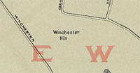
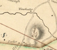
| Winchester Hill |
| • |
USGS identified - MassMapper MassGIS |
| • |
Google Maps | Google Earth - Google |
| • |
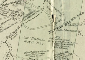
"...Returning northwestwardly, we come to the Governor Haynes'
farm (1634), which formed nearly a rectangle, embracing one
thousand and thirty-four acres...On the southerly part of this farm was Stephen Winchester (1720), - successors, Stephen Winchester, jr. , Amasa Winchester, Amasa Winchester.......", Smith, pg. 120, 1880 - Internet Archive |
| • |
"... In this pastoral region, between Winchester Street and Dedham Street, and south of the brook, is the long ridge formerly known as Winchester Hill, from a farmer who dwelt hard by...", Sweetster, pg. 325, 1889 - Internet Archive |
| • |
Winchester Hill - USGS Geographic Names Information System |
|
|
|
 |
|
 |
|
 |
|
| Bellevue Knoll |
 |
|
 |
|
| Chestnut Hill |
 |
|
 |
|
 |
|
| Heartbreak Hill |
 |
|
| Hemlock Gorge |
 |
|
| Institution Hill |
 |
|
 |
|
 |
|
 |
|
| Mount Ida |
 |
|
 |
|
| Nonantum Hill |
 |
|
| Oak Hill |
 |
|
| Winchester Hill |
 |
|
 |
|
| |
| |
| |
| |
|
|
| More about Newton's USGS-listed hills |
|
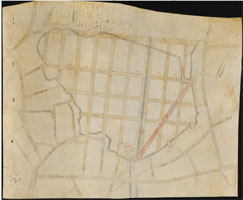
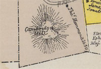
When Newton was settled in 1630 it was part of the “New Town” that would be renamed Cambridge in 1638. In 1679, the part of Cambridge south of the Charles River was incorporated as a separate town and called Cambridge Village, or sometimes New Cambridge. in 1691, the old name New Town was restored and finally, and officially, the name became Newton in 1766. Newton became a city in 1873. Newton has ten USGS-listed hills. Two of them, Moffatt Hill (108 ft.) and Winchester Hill (207 ft.), are named after an historical figure. John Winchester (1616-1694) immigrated to New England in 1636, first settling in Hingham. He married Hannah Sealis (1615-1698) of Scituate in 1638.1 The family moved to Muddy River, today’s Brookline, around 1650 possibly to get away after Winchester, along with many others in Hingham, had been fined for “military troubles.” The issue was more an ecclesiastical and political struggle between Hingham church leader, and town founder, Peter Hobart and then Deputy Governor John Winthrop, representing the Massachusetts colonial government. The case that made it to court was who had the right to designate the leader of the local militia. Hobart argued for the right for the town to make the choice, and when his supporters participated in drill sessions run by a different leader than the one chosen by Massachusetts colonial officials, Winthrop pressed charges. Hobart lost, and fines were levied to Winchester and 80 other men. |
|
John Winchester’s oldest son, John Winchester, Jr. (1642-1717), became a prominent citizen in Muddy River and was one of the signers of the petition to have Brookline set off as a separate town in 1705. He married Joanna Steven (1652-1718), and their youngest son, Stephen Winchester (1686-1751), moved to the Newton Upper Falls area in 1720 buying land near what would become known as Winchester Hill. The land was a portion of a 1,000-acre grant Johns Haynes (1594-1653) had received after he immigrated to New England in 1633. He was the fifth Governor of the Massachusetts Colony serving one year from 1635 to 1636. Almost a footnote in Massachusetts history, Haynes has the unusual distinction of also being the first governor of the Colony of Connecticut. A member of the landed gentry in England with significant personal wealth, he traveled to New England aboard a ship with prominent Puritan religious leaders Thomas Hooker (1586-1647), John Cotton (1585-1652), and Samuel Stone (1602-1663). Settling in New Town (Cambridge) he quickly became involved in local politics astutely running for governor promising lower taxes. Aligning himself with his friend Thomas Hooker in affairs of the colony put him in conflict with the faction lead by John Winthrop and John Cotton. Hooker and Samuel Stone would leave Massachusetts in 1636 settling just north of a Dutch fort on the Connecticut river in a town they named Hartford. Haynes would follow a year later. He would serve as governor from 1639-1654 in alternating one-year terms. Winchester Hill is not identified on any historic USGS topographic map. Nor is not shown in the 1871 Walling & Gray Massachusetts atlas from the USGS citation. It is shown in an 1831 W.F. Ward map of Newton, and the 1891 O.W. Walker atlas of the state. |
|
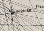
Moffatt Hill is the other USGS-listed summit in Newton with an historical surname, though in the case Moffatt, there is little information on who he was, not even his first name.2 In addition, Moffatt Hill moved. Of course, the hill didn’t really move. Around 1900 the name of Moffatt Hill was changed to Beacon Hill. That’s not unique, what is unique was that the name was reissued to a different hill in Newton that had nothing to do with Moffatt. The King’s Handbook of Newton, written in 1889 by Moses F. Sweetser, does not present Moffatt in a favorable light saying he “squatted” on the land and was “a very odd body, living quite by himself, with the exception of a horse, a cow, and a couple of dogs that occupied the same room in his miserable hut.” He claimed the new name, Beacon Hill, was based on the placement of a tall beacon on the hill for a U.S. Coast Survey and Massachusetts State Survey. It might have just been a pole because the hill also has been known as Flagstaff hill for a flag flown there during the Civil War. The hill is a good distance inland, so it seems unlikely to be part of coastal survey. The hill was used as triangulation marker for the 1904 Massachusetts Atlas of the Boundaries of the City of Newton. But they gave it a different name, Strongs Hill. That name provides a clue on why the hill’s name was changed. |
|
When the Board of Harbor and Land Commissioners of Massachusetts in 1904 published their Boundary Lines report that included Newton, what had been named Moffatt Hill was now on land now owned by William C. Strong (1823-1913). The name they gave it, Strongs Hill, wouldn’t stick. In the 1893 USGS topographic map the hill was named Moffatt Hill, in the 1903 report, its Beacon Hill. Strong in the late 1880s had given up the law profession and was now a gentleman farmer horticulturist and land developer. By 1885 he had sold off all his personal and business property in Brighton and purchased land in a rural farming section of Newton between the villages of Newton Upper and Lower Falls. The 100-acre farm he purchased included Moffatt Hill. Strong went on to have a major role in the village, including suggesting the name Waban, playing a role in convincing the railroad to establish a station there, having Beacon St. extended to the village, and involvement in residential, commercial, civic, and religious buildings and development. He continued his interest in horticulture becoming president of the Massachusetts Horticultural Society, a member of the American Pomological Society (the study and cultivation of fruit), and provided landscaping plantings throughout the village from his nurseries of Moffatt Hill. Why they didn’t hill keep the name from the survey is not known. It is easy to understand why Strong and the other Waban land developers didn’t want the prominent physical feature in their new town be named after a squatter. And the “new” Moffatt Hill, the USGS citation lists the noted historian’s 1965 book, New England Frontier: Puritans and Indians, 1620-1675. The same citation is used on multiple hills on the northern border of the Boston Basin, and like all of those, the hill is not mentioned in the book. |
|
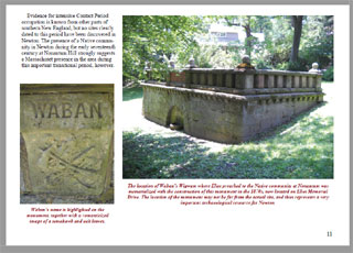
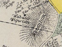
Two hills in Newton have Native-American names, Nonantum Hill (190 ft.) and Waban Hill (318 ft.). Both relate to the group of Native Americans who converted to Christianity in 1631.3 Waban was the Native American spiritual lead who first met with Rev. John Eliot at Nonantum Hill and converted. Waban is thought to mean “east” or “east wind”. Nonantum has been translated as “praying place” or “I rejoice”. The location of where Eliot first met Waban has been described as, “the hill at the foot of which now lies the village called Newton Corner”, “a little west of Oak Square, Brighton”, and “southwest slope of Nonantum Hill (on the present Brighton-Newton boundary)”. Then there is the Eliot Memorial monument overlooking the Newton Commonwealth Golf Course engraved on it “near this spot” citing as a source letters written by John Eliot. All these descriptions point to similar location which is no where near where the USGS gives for Nonantum Hill well west near the Needham line south of Newton Upper Falls. The USGS citation for the its location of Nonantum Hill is the catch-all Alden T. Vaughan book. The USGS lists a Nonantum as Populated Place located north and west the Eliot Memorial nearer Watertown and the Charles river. It also has an historical listing for another Nonantum Populated Place, this one Historical with only a description, “Formerly located on Nonantum Hill near Newton” for a location. The citation for this one is a 1907 book written by Frederick W. Hodge for the Smithsonian Institution. Assuming that the Eliot monument is the correct location for Nonantum, the hill that matches the descriptions is the modern day Farlows Hill. And the monument is on land that belonged to John Kenrick, who ran in the early 1800’s a successful nursery business (fruit trees a specialty) and farm there. Though there is no USGS listing for Farlows Hill, and on some maps the hill is called Nonantum Hill. Waban Hill, up until 1875, it was known as Prospect Hill. The name was changed when a reservoir was built on its side. The name change possibly was to eliminate confusion with other USGS-listed Prospect Hills in Lynn, Somerville, and Waltham. There are addition USGS Waban listing for a Dam and Reservoir on the hill, and for William Strong’s Waban village Populated Place. |
|
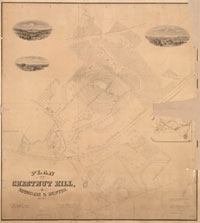
The first settlers on Chestnut Hill (282 ft.) where two other men from Hinham like Winchester who had “military troubles” and moved to Cambridge Village in the mid-1650s. Thomas Hammond (1603-1675) and Vincent Druce (?-1678) jointly purchased land that had been granted to, but never by settled on, Robert Brodish and Nathaniel Sparhawk.4 The area was called Cambridge Village at that time, and the hill was called Cambridge Hill. The next name for the hill that appears in the records is Lee’s Hill in a 1856 map of Middlesex County by H.F. Walling. Early maps from 1831 and 1848 show a Lee living next to the hill. The Lee is Joseph Lee, Jr. (1770-1845), the eldest son of Joseph Lee (1744-1831) and Elizabeth Cabot (1748-c.1786), both from wealthy Cape Anne merchant families. Joseph Lee, Jr. was a sea captain and merchant who bought land on the hill in 1822. When he died a bachelor in 1845, the heirs, his nieces and nephews, decided to break up the farm and subdivide the land for homes. The same Newton Circuit railroad that would spur the growth of Waban also had a stop in the new village of Chestnut Hill. They family asked one of their own, Francis L. Lee (1823-1886), to supervise the supervise and it was he who named the area Chestnut Hill for the large chestnut trees that grew on the land. Francis, a Harvard graduate, was as a profession, a landscape gardener, this before landscape architecture was a degree-based career. Frederick L. Olmsted, one of the first Americans to call himself a landscape architect, designed the train station. The financing came from the family bank, Lee, Higginson & Co. Francis, a scion of wealth, and his wife Sarah Wilson (1821-1901) along with a house they built in Chestnut Hill, also owned a townhouse in Back Bay and a summer house in Westport, N.Y. on Lake Champlain. As a side note, it was Francis and Sarah’s son came up with the idea for the Adirondack chair. |
|
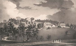
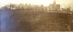
In 1825, the Northern Baptist Education Society purchased a tract of land on a hill in Newton for the establishment of a seminary to be called the Newton Theological Institution. All historic USGS topographic maps have identified the location of the institution, but not called it a hill until the 2015 map which added the Institution Hill label. The Institution Hill label is used in the 1874 G.M Hopkins & Co. Atlas of the City of Newton. The USGS-lists an Institution Hill (197 ft.) and a Newton Theological Institution Historic District (289 ft.). Neither are based on geographic surveys. The Institution Hill listing uses the catch-all Alden T. Vaughan citation, and places the summit east of the actual location. The Historic District listing gets the location correct, and likely is closer to the correct elevation. Its citation is the National Register of Historic Places. The hill had been the home of John Peck (1770-1847) and Elizabeth (Gilman) Peck (1781-1861).5 Joseph Grafton (1757-1836), pastor of the First Baptist Church in Newton, and founder of the Theological Institution, is quoted making a backhanded joke about the financial troubles that forced Peck to sell his house. This is unfair to the legacy of John Peck. By the time he and his family moved to Lexington, Ky. in 1815, John Peck had seen action in the Revolutionary war serving with his father as a 10-year old cabin boy on Continental Navy ships, been captured twice, escaped twice, have his father be killed in the war, and then after the war, establish a career that would have a major impact on Boston and the country. After the war, Peck’s mother remarried, and John followed his new step-father becoming a broker in Boston dealing with public securities and land purchases. Successful at business, in 1798 Peck bought the hill in Newton and, after he married Elizabeth in 1801, built a country estate on the summit with a large house with elaborate gardens. A house that Baptist seminary were happy to use when they bought to so-called “Peck’s folly” property 15 years later. |
|
One of first of the many steps that it took to increase the land area of Boston was the filling of the Mill Pond. It was John Peck who in 1804 created the Boston Mill Corporation to accomplish that task. The population of Boston had almost doubled from about 15,000 in 1750 to 30,000 in the early 1800s. By that time the mills were in disrepair, and the tidal pond area was polluted. In 1808 Peck presented to town officials a plan for a reclaimed Mill Pond drawn by noted architect Charles Bulfinch. It would end taking almost 20 years, the top of Beacon Hill, and much political haggling, for the project to be completed. Peck and family had left for Kentucky before its competition, but no before being involved in another business opportunity that would have a national impact, the Yazoo land scandal. In 1795 the Georgia legislature sold 35 million acres of land in the state’s western territory (present-day Alabama and Mississippi) to four local private land companies at the incredibly low price of 1.25 cents an acre. Those companies resold the land at a profit to other companies, including the New England Mississippi Land Company run by John Peck and Edward Stow (Stow had married Peck’s sister Ann). They then further resold title to the land to more investors. After accusations of corruption in Georgia were proven, the legislature voted to rescind the act in 1795, and sold the land to the federal government. The New England Mississippi Land Company and the other speculators were left with a large debt and worthless titles. Efforts by the companies to find a resolution were stymied by squabbling in the U.S. Congress and a law which prevented appealing territorial court decisions to the Supreme Court. Thanks to some enterprising legal minds, the New England Mississippi Land Company came up with a way to have the case resolved by the Supreme Court. Robert Fletcher, a shareholder in Peck’s land company who he lived in New Hampshire, feigned a breach of contract with Peck accusing him of selling him land that Peck didn’t really own. Local civil actions couldn’t reach the federal court, but inter-state breach of contract actions could. The case of Fletcher v Peck reached the Supreme Court in 1810, and in a decision that both Fletcher and Peck wanted, the court ruled that Georgia had violated the Constitution by rescinding the original contract. It was a landmark decision, the first time a federal court had invalidated a state law. Likely contributing to successful of the case for Peck was the fact that Chief Justice John Marshall was a federalist and land speculator, Peck’s legal team included future President John Quincy Adams and future Supreme Court Justice Joseph Story, and Fletcher’s case was argued by Luther Martin of Maryland, who the Court had to adjourn for several times because he came drunk. In end, neither Fletcher or Peck wanted the titles for the land. They wanted compensation and that finally came in 1814 when the U.S. Congress approved a $5 million for the claimants. The timing on when Peck left for Kentucky, 1815, might not be a coincidence. |
|
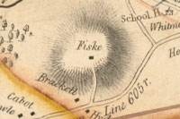
Three names are most commonly associated with the USGS-listed Mount Ida (194 ft.), John Fiske, Langdon Coffin, and George F. Jewett. The Fiske family has been in New England since the 1640s.6 David Fiske (1624-1710) was a wheelwright and surveyor. He was one of selectmen in Cambridge who voted for the creation of Cambridge Village (today’s Newton) in 1688. Later he would move to Cambridge Farms (today’s Lexington). There is a USGS-listed Fiske Hill in that town. David’s brother, Nathan Fiske, was a resident of Watertown. He also was a selectman and surveyor, and Watertown has a non-USGS listed Fiske Hill. In the 1889 King’s Handbook of Newton, Sweetster says a John Fiske bought that hill that would become Mount Ida in 1816 for $10,000, and his name appears on the 1831 W.F. Ward map of Newton living directly on top. The naming of is credited to Langdon Coffin (1807-1874).7 He was a descendant of Tristam Coffin (c. 1609-1681), who arrived in America from England in 1642 as one of the founders of Nantucket. Langdon’s father, Edward L. Coffin (1783-1834) was a shipmaster in Gloucester. Coffin had bought and laid out the hill for development after the Civil War. The nearby railroad line, seen today running next to the Massachusetts Turnpike, provided the potential for residential growth in the then rural area. In 1850, Coffin had built a house in a new Newton development named Woodland Vale. Located on western slope of Brighton’s Nonantum Hill, the land had long been the nursery of noted horticulturist William Kenrick (1789-1872). In 1867 Coffin sold the house and his other property there but would return to Newton when he created the new subdivision on Mount Ida. Why he named the hill Mount Ida is not known. The historical record on Langdon Coffin is slim. More information is known about brother, William E. Coffin, because was a member of the New England Historic Genealogical Society. Langdon identifies himself as a real estate developer and home builder in the 1860s. Assuming there were no other Langdon Coffin’s in Boston at that time, these are other professions he is shown as having; a book seller in 1832, shoe dealer in 1834, bank messenger in 1837, and a broker in 1848. The first job on record might supply a hint why he named the hill Mount Ida. A Langdon Coffin is in the WorldCat library catalog as the publisher in 1831 of a Bible, and an edition of John Milton’s epic poem, Paradise Lost. On page 17 Milton talks about Ida in Crete, the birthplace of the Greek god Zeus. Ida in Greek means wooded hill. When George F. Jewett (1857-1926) and his wife Abigail (Fay) Jewett (1852-1942) located their school for girls on the hill in 1899, they named it after the hill.8 |
| USGS-listed Bald Pate Hill (289 ft.) and Oak Hill (282 ft.) are located in the southern part of Newton near the border with Brookline. Both hills have been called by those names since the first European settlers moved into the area in the 1600s. Both hills are glacial drumlins made up of compacted clay, silt, sand, gravel, and boulders. So Bald Pate Hill, literally “bald head,” did not earn its name from any bedrock outcropping. Both hills were forested, and it is said that in the case of Bald Pate, a thinning of the forest on its summit made the rounded outline visible from below. Located in an area primarily dedicated to farming up until the second World War, both hills remained vacant land much longer than elsewhere in Newton. For both hills a single home would be built on their summit. And in both cases, there is a darker story to the families that first owned them. |
|
In 1886 noted American architect Henry H. Richardson, as one his last residential commissions, designed a 2-1/2 story rambling shingle-style house on top of Oak Hill for Henry J. Bigelow (1818-1890).9 The son of botanist and physician Jacob Bigelow (1787-1879), Henry became a leading surgeon at Massachusetts General Hospital and a professor of surgery at the Harvard Medical School. Responsible for numerous medical advancements, he is best known for promoting the use of anesthesia in surgical procedures. He is one of the men in the famous painting of the first use of inhaled ether as a surgical anesthetic on October 16, 1846. Despite the medical successes in the medical professions, Henry J. Bigelow’s life would have a tragic side. In 1847, Henry married Susan Sturgis (1825-1853), the youngest child of William F Sturgis (1782-1863), another of the Boston merchants who became wealthy in the China trade. The would have one child, William J. Bigelow (1850-1926), but with rumors of Henry’s infidelity, the marriage would collapse. At twenty-seven Susan, separated from her husband and pregnant with their second child, would commit suicide. Henry would continue to have a remarkable career retiring in 1886. But he would not be able to enjoy his new house on Oak Hill for long dying in 1890. After his death, his estate would be sued by a woman who had Henry when she was 23 years old and he 50, and that they had a verbal agreement to get married. The trial received extensive covered in the press, with the plaintiff losing her case. |
|
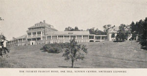
After William’s death, his son Henry inherited the house and rented it to James J. Storrow (1864-1926). He was a prominent Boston-based lawyer and investment banker. It was Storrow who began the campaign to dam the Charles river and create the Charles River Basin. Storrow Drive is named after him. Owners of the Bigelow property on Oak Hill include Horace K. Turner (c.1873-1918).10 He ran an art publishing company that produced reproductions of fine art made by hand coloring black and white copies made using either early bromide-based photographs or photogravure prints. In 1908, to provide good light and healthy conditions for his artists, he constructed a long curving bungalow-style building contoured to the hill. The company went bankrupt in 1912. Another interesting owner of the property was Earle L. Ovington (1879-1936).11 He is credited in 1911 with piloting the first official airmail flight in the United States. In 1919, the property was acquired by the New England Peabody Home, an orthopedic hospital for children who had polio, bone tuberculosis, infantile paralysis, severe accidents and birth defects. Founded by Harriet M. Peabody in 1895 in Weston, Mass., the home moved to Hyde Park, Mass. in 1900, then to Oak Hill.12 Advances in treatment reduced the need for a separate institution, so in 1961 the institution closed, sold the property and donated the proceeds to the Harvard Medical School creating the Harriet M. Peabody Professorship of Orthopedic Surgery. The City of Newton would use property until it was boarded up in 1974. The Bigelow house would be saved in 1981 when it was selected to be renovated and converted to condominiums by Bob Vila’s on his This Old House show. The Peabody Home would also be converted to condominiums separately. |
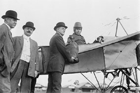
| Bald Pate Hill would not see development until 1930 when a lot on the summit was purchased and house built by Ernest B. Freeman (c.1878-1958).13 Born in Worcester, he started work as an engineer at B.F. Sturtevant Co., an early manufacturer of large ventilating equipment used in building, factories, and ships. Freeman would rise in the company to become general manager, and then president. Like Earle Ovington on Oak Hill, there is a connection Freeman had to the early aircraft industry. He was a director of the Boston-based Sturtevant Aeroplane Co. Initially formed to build aircraft and marines engines, the company expanded to build complete airplanes in 1915 as part of an effort to win a competition for an Army and Navy contract. The company met with some limited success, but a crash during a test flight dimmed the prospect of the plane’s acceptance. The accident did demonstrate Sturtevant’s use of steel over wood in the construction of a plane improved safety, and because of this the company received substantial orders during the war as a subcontractor for other companies’ planes. One less savory similarity between Henry Bigelow on Oak Hill and Ernest Freeman on Bald Pate Hill is a contentious martial dispute covered extensively by the press. Bigelow wasn’t alive for his lawsuit, Freeman was. A judge would rule against him, possibly influenced by Freeman’s daughter who on the stand said her father “liked pretty girls.” |
|
While not a hill, the Hemlock Gorge of the Charles River has a unique place in history in the Boston Basin as a part of the original plan for a park system proposed by the newly-created Metropolitan Park Commission in 1893. Classified by the USGS as a gap, a “low point or opening between hills,” it is one of only three in the Boston Basin. The others are Slide Notch and Wildcat Notch in the Blue Hills Reservation. Noted landscape architect Charles Eliot (1859-1897) and journalist and urban planner Sylvester Baxter (1850-1927) are considered to be the driving forces in creation of Metropolitan Park Commission, later called the Metropolitan District Commission, and today’s Department of Conservation and Recreation.14 It was Baxter who proposed the idea of a metropolitan Boston land area made up of not only the city of Boston, but also all of the towns and cities with a 10-mile radius which he saw as a “great sea of buildings” which “has swollen beyond the capacity of its basin.” It was then Eliot who identified the need of the population of this basin for parklands beyond just “public gardens, square, or ball-field.” Specifically, a preservation of the fast disappearing native wilds of the area. Baxter is credited with naming the Middlesex Fells park, and Eliot talks about a stream the "flows darkly between rocky and broken banks from which hang ranks upon ranks of graceful Hemlocks." The area that would officially become protected as the Hemlock Gorge Reservation in 1895 was already a popular picnic spot as early as the 1870s. Near the village of Newton Upper Falls, the Boston Worcester Turnpike (today’s Route 9) was nearby, and soon would be a train stop on a new railroad line. Also, the gorge was next to the recently completed Echo Bridge, part of the Sudbury Aqueduct created to bring water to Boston. |
|
|
| Newton Maps |
| • |
Newton - Google Maps, Terrain |
| • |
Newton - MassMapper MassGIS |
| • |
Newton - USGS - The National Map |
| • |
Natick Quadrangle - 2018 (60 MB PDF) - USGS Topo Download |
| • |
Newton Quadrangle - 2018 (60 MB PDF) - USGS Topo Download |
| • |
Plan of the Town of Newton in 1700, Geo. H. Walker & Co., c. 1830 - Newton Free Library, Digital Commonwealth |
| • |
Map of Town of Newton, Mass., W.F. Ward, 1831 - Norman B. Leventhal Map Center, Boston Public Library |
| • |
Map of Middlesex County, Massachusetts, Henry F. Walling, 1856 - Library of Congress |
| • |
Atlas of the Massachusetts, pg. 44-45 Walling & Gray, 1871 - State Library of Massachusetts |
| • |
Atlas of the City of Newton, Mass., G.M. Hopkins & Co., 1873 - State Library of Massachusetts |
| • |
Atlas of the Massachusetts, pg. 58-59, O.W. Walker, 1891 - State Library of Massachusetts |
| • |
Atlas of the City of Newton, Mass., G.W. Bromley & Co., 1895 - State Library of Massachusetts |
| • |
Atlas of Middlesex County, Mass., Index pg. 36-37, Geo. W. Stadley & Co., 1900 - State Library of Massachusetts |
| • |
Atlas of the City of Newton, Mass., G.W. Bromley & Co., 1907 - State Library of Massachusetts |
| • |
Atlas of the City of Newton, Mass., G.W. Bromley & Co., 1917 - State Library of Massachusetts |
| • |
Atlas of the Massachusetts, pg. 50-51 G.H. Walker, 1922 - State Library of Massachusetts |
| • |
Historic Maps of Newton - City of Newton, Massachusetts |
| • |
Historic Maps of Newton, MA - John Fuller |
|
|
| Newton Sources |
| • |
History of Newton, Massachusetts, Town and City, from its Earliest Settlement to the Present Time, 1630-1880, Samuel F. Smith, 1880 - Internet Archive |
| • |
King's Handbook of Newton, Moses F. Sweetser, 1889 - Internet Archive |
| • |
Newton, History of Middlesex County, Massachusetts: Containing Carefully Prepared Histories of Every City and Town in the County, Samuel A. Drake, 1880, Vol. 2 - Internet Archive |
| • |
Newton, History of Middlesex County, Massachusetts, with Biographical Sketches of Many of its Pioneers and Prominent Men, Duane Hurd, 1890, Vol. 3 - Internet Archive |
| • |
The Newtons, F.W. Burrows, The New England Magazine, Vol. 39, pg. 549, 1909 - Google ebook |
| • |
A History of the Early Settlement of Newton, County of Middlesex, Massachusetts, from 1639 to 1800, Francis Jackson, 1854 - Internet Archive |
| • |
The Mirror of Newton Past and Present, Newton Federation of Women's Clubs, 1907 - Internet Archive |
| • |
Beautiful Newton, The Garden City of Massachusetts, John C. Brimblecom - Internet Archive |
| • |
Walks and Rides in the Country Round about Boston, Edwin M. Bacon, 1898 - Internet Archive |
| • |
Jackson Homstead Newton Older Houses, Remaining in 1972, Newton Upper Falls 1972, Auburndale 1974, Newton Corner and Nonantum 1976, Newton 1978 - Internet Archive |
| • |
The Geology of Newton, James W. Skehan, S.J. and Catherine W. Barton - City of Newton |
| • |
Newton: Images of America, Thelma Fleishman, 1999 - Google book preview |
| • |
City of Newton Open Space and Recreation Plan, 2020-2027 Update (PDF) - City of Newton |
| • |
Newton, MHC Reconnaissance Survey Town Report (PDF), 1981 - Massachusetts Historical Commission |
| • |
Newton Conservators |
| • |
City of Newton City-Wide Archaelogical Reconnaissance Survey, (PDF), 2011 - City of Newton |
|
|
| Footnotes |
| 1 |
John Winchester, Jr., pg. 6, Winchester Notes, Fanny W. Hotchkiss, 1912 - Google ebook |
|
My Winchester Family of Brookline, Annie B. Winchester, Proceedings of the Brookline Historical Society, 1927 - Brookline Historical Society |
|
John Winchester, pg. 83, History of the Military Company of the Massachusettsn, Vol. 1, 1637-1738, 1895 - Internet Archive |
|
John Haynes, 1st Governor of the Colony of Connecticut - Museum of Connecticut History |
|
John Haynes, 1st Governor of Connecticut, Charles E. Cuningham, The New England Quarterly, Vol. 12, No. 4 (Dec. 1939) - JSTOR |
|
The Ancient Governor Haynes House, Cambridge Tribune, Volume XXVIII, Number 39, 25 November 1905 - Cambridge Public Library |
|
John Haynes, The Governors of Connecticut, Frederick C. Norton, 1905 - Online Biographies |
| 2 |
The Early Days, History and Tradition of Waban, Lawrence W. Strong, 1875 - Waban Improvement Society |
|
Cultivation of the Grape, W.C. Strong, 1867 - Internet Archive |
|
William Chamberlain Strong, American Pomological Society, Proceedings, Vol. 33, pg. 291, 1913- Google ebook |
|
The King’s Handbook of Newton, M.F. Sweetser, 1886 - Waban Improvement Society |
| 3 |
Nananeetum; "Rejoicing", pg. 52, Nonantum and Natick, Sarah S. Jacobs, 1853 - HathiTrust |
|
Our History - Praying Indians of Natick and Ponkapoag |
|
1651-2001, 350th Anniversary of Natick, Massachusetts and the
Natick Praying Indians - A. Richard Miller |
|
Waban, the Wind, Arthur M. Southwick - Waban Improvement Society |
| 4 |
A Brief History of Chestnut Hill, Pete Begans, The Heights, Volume LV, Number 3, 16 September 1974 - Boston College Libraries |
|
Chestnut Hill, Linda O. Pehlke, 2005 - Brookline Historical Society |
|
The Hammonds, pg. 176, Volume 1, Family and Mormon Church Roots: Colonial Period to 1820, - Google ebook preview |
|
Capt. Joseph Lee, The New England Historical and Genealogical Register, pg. 205, 1922 - Google ebook |
|
Death of Francis L. Lee, Landscape-gardener, The American Architect and Building News, pg. 176, 1886 - Google ebook |
|
Francis L. Lee Papers - Massachusetts Historical Society |
|
The history of the Adirondack chair - Chasie Adirondack |
| 5 |
Robert Maynard Peck, Midshipman & John Peck, Boy, Joseph Ross, 2013 - ContinentalNavy.com |
|
John Peck, History of the Military Company of the Massachusetts, now called the Ancient and Honorable Artillery Company of Massachusetts, 1637-1888, Vol. 2, 1897 - Internet Archive |
|
Gaining Ground: A History of Landmaking in Boston, Nancy S. Seasholes, 2003 - Google ebook preview |
|
The North End: A Brief History of Boston's Oldest Neighborhood, Alex R. Goldfeld, 2009 - Google ebook preview |
|
Boston Mill Corporation Records, 1643-1878 - Harvard University Library |
|
The Boston Mill Corporation (PDF) - The West End Museum |
|
Site Through Time, The Bulfinch Triangle, The Once and Future City, Anne W. Spirn, 2018 - School of Architecture and Planning, Massachusetts Institute of Technology |
|
Boston’s Mill Pond Massachusetts Historical Commission |
|
The Yazoo Contract, The Second Bank, and The Steamboat Monopoly (PDF), David M. Freedman, 2016 - Freedman-Chicago Publishing |
|
Jan. 7, 1795: The Yazoo Land Fraud Becomes Law, Allen Pusey, 2018 - ABA Journal |
|
Yazoo Land Fraud - GeorgiaInfo |
|
Yazoo Land Fraud, George R. Lamplugh, 2002 - New Georgia Encyclopedia |
|
The Great Yazoo Lands Sale: The Case of Fletcher v. Peck, Charles F. Hobson, 2016 - JSTOR |
| 6 |
Fiske, William R. Cutter, Historic Homes and Places and Genealogical and Personal Memoirs, Vol. 4, pg. 1532, 1908, - Google ebook |
|
Fiske and Fiske Family, Frederick C. Pierce, 1896 - Internet Archive |
|
Coming to America - The Fiske Family Association |
|
Fisk and Fiske Descendants in America - The Timetable Trust Catalog |
|
Nathan Fiske, Sr. - An American Family History |
| 7 |
Langdon Coffin, John Thomas Wells House - Massachusetts Historical Commission Information System (MACRIS) |
|
Banks in Boston, Freeman's Bank, The Boston Almanac for the Year 1837 - Google ebook |
|
Stimpson's Boston Directory, pg. 112, 1832 - Google ebook |
|
Massachusetts, Citizens of Boston, Currency, pg. 36 , House Documents, 1834 - Google ebook |
|
The Boston Directory, pg. 172, 1872 - Google ebook |
|
Author, Langdon Coffin - OCLC WorldCat |
|
Private and Special Statutes of the Commonwealth of Massachusetts, Volume 11, pg. 2, 1860 - Googfe ebook |
| 8 |
George Franklin Jewett, Jewett and Allied Families, Americana, American Historical Company, Vol. 23, g 210, 1909 - Internet Archive |
|
History of Mount Ida College - Mount Ida College |
| 9 |
Henry Jacob Bigelow - The Bigelow Society |
|
Bigelow, Henry Jacob, MD - Massachusetts General Hospital |
|
Henry Jacob Bigleow, Proceedings of the American Academy of Arts and Sciences, Oliver W. Holmes, Vol. 26, 1891, pg. 339 - JSTOR |
|
Henry J. Bigelow - Utopian Surgery |
|
A Tale of Two Paintings: Depictions of the First Public Demonstration of Ether Anesthesia, Sukumar P. Desai, Manisha S. Desai, Rosemarie Maddi, George E. Battit, 2007 - Anesthesiology |
|
Clover Adams: A Gilded and Heartbreaking Life, pg. 19, Natalie Dykstra, 2012 - Google ebook preview |
|
Feared Designs, Boston Daily Globe, Oct. 19. 1894 - The Boston Globe |
|
Very Contradictory, Boston Daily Globe, Oct. 20. 1896 - The Boston Globe |
|
Bartlett-Bigelow Case, Boston Daily Globe, Nov. 13, 1896 - The Boston Globe |
|
Miss Bartlett's Suit Again, Feb. 20, 1896 - The New York Times |
|
“Samurai Bill,” The Third Bigelow, Ray J. Defalque, Amos J. Wright, Bulletin of Anesthesia History, Vol. 23, No. 5, 2005- ResearchGate |
|
Tuckernuck's Resident Millinaire Buddhust, three parts, James Grieder, 2012 - Nantucket Chronicle |
|
The Newton House, Caitlin O'Neil - This Old House |
|
The Bigelow House, Bob Vila's This Old House - Google ebook preview |
| 10 |
Art Exhibit Catalog, 1907-1907, Horace k Turner - Internet Archive |
|
Horace K. Turner - OCLC WorldCat |
|
Horace K. Turner Art Publishing Company - Massachusetts Historical Commission Information System (MACRIS) |
| 11 |
Earle Ovington: Pilot of the First Official Airmail Flight in the United States, Christopher Knudsen - Smihtsonian's National Postal Museum |
|
Earle Ovington Was First - Air Mail Pioneers |
|
Earle Ovington: “Air Mail Pilot No. 1” - The Henry Ford |
|
Earle Lewis Ovington - The Early Birds of Aviation |
|
News from the Classes, Massachusetts Institute of Technology, Technology Review, Volume 17, pg. 123, 1915 - Google ebook |
|
Dangerous Stunts of Early Flying Competitions - YouTube |
| 12 |
Harriet M. Peabody Professorship of Orthopedic Surgery 1962, pg. 239 (PDF), Harvard University History of Named Chairs - Harvard University |
|
New England Peabody Home - Massachusetts Historical Commission Information System (MACRIS) |
|
New England Peabody Home For Crippled Children - Janice Karin |
| 13 |
B.F.Sturtevant History - Sturtevant, America's First Fan Company |
|
The.Sturtevant Aeroplane Company, pg. 229 (PDF), The Aircraft Yearbook for 1919 - Aerospace Industries Association |
|
Sturtevant Aeroplane Company - The Massachusetts Aviation Historical Society |
|
Sally Freeman Testifies Her "Father Like Pretty Girls", Boston Daily Globe, Jan. 24, 1920 - The Boston Globe |
| 13 |
Charles Eliot, Landscape Architect, Charles W. Eliot, 1902 - HathiTrust |
|
Charles Eliot - The Cultural Landscape Foundation |
|
Report of the Landscape Architect, Charles Eliot, Report of the Board of Metropolitan Park Commissioners, pg. 82, 1893 - HathiTrust |
|
The Waverly Oaks: A Plan for their Preservation for people, Charles Eliot, Landscape Architect, pg. 316, 1902 - Googe ebook |
|
Sylvester Baxter - The Cultural Landscape Foundation |
|
Metropolitan Park System of Greater Boston - National Park Service |
|
Cooperative Schemes for Greater Boston: 1890-1920, James A Merino, The New England Quarterly, Vol. 45, No. 2, 1972 (PDF) - JSTOR |
|
|